Mithril Expands Silver Rich Target 5, Sampling up to 3,300 g/t Silver, 2.0 g/t Gold over 1.30m

Sampling expands silver-rich Target 5 to over 2 km x 2 km; assays pending for drilling at both Targets 1 and 5
Melbourne, Australia and Vancouver, British Columbia–(Newsfile Corp. – October 9, 2025) – Mithril Silver and Gold Limited (TSXV: MSG) (ASX: MTH) (OTCQB: MTIRF) (“Mithril” or the “Company”) is pleased to provide exploration results and update for multiple targets at Mithril’s district scale Copalquin property, Durango State, Mexico.
Highlights
-
First nine holes completed at Target 5 (assays pending)
-
Sampling and mapping at Target 5 expand the silver-rich Target to over 2 km x 2 km, with highlights up to 3,300 g/t silver and 2.00 g/t gold over 1.40 m from the historic Tasolera mine. Resource expansion drilling at Target 1 successfully extends the east-west mineralised structure a further 300 m west increasing the total strike length to over 1,200 m (assays pending)
-
Target 3 drill plan advancing with pads and access roads under development
-
District wide aerial magnetic survey to commence later this month
-
A petrographic fluid inclusion study is currently underway on samples collected from multiple locations and depths across the property support the district scale geologic model development
-
The mineralised horizon is currently extended to over 1,300 metres vertical across 9 km (Santa Cruz to El Jarillal) in the southern half of the Copalquin district
“Drilling at the silver rich Target 5 is off to a strong start, with the first nine holes now complete at the historic Apomal mine area (assays pending),” commented John Skeet, Managing Director & CEO. “Results from previous sampling across the broader area continue to return standout silver grades, confirming a much larger mineralised target now covering over two kilometres across.
At Target 1 we have successfully extended the main structure a further 300 metres to the west (assays pending), adding strike to an already substantial high-grade resource area. Preparations for maiden drilling at Target 3 are advancing quickly, opening another significant growth opportunity in the coming months.
In parallel, we are accelerating development of the district-scale geologic model to test for the underlying conduit system responsible for the widespread gold-silver mineralisation, supported by the launch of the first district-wide aerial magnetic survey.”
District Outlook
Mithril is fully funded to complete 45,000 m of drilling over the next 12-14 months, with preparations to add a third drill rig in early 2026 at Target 3. Exploration, including drilling and detailed mapping, continues to advance across multiple targets, underpinning the district-scale potential of Copalquin. A closely spaced aerial magnetic survey is to be flown later this month and a petrographic fluid inclusion study on samples across the district will support the ongoing development of the district scale model for this large epithermal gold-silver system
Target 5 – Silver Rich in Southwest of Copalquin District
Drilling continues around the Apomal historic mine in the Target 5 area, with the first nine holes completed (assays pending) in an initial 5,000 metre program. Apomal is being tested down dip, below the old mine workings and along strike in the north western part of this large target area. This program marks the first drilling at Target 5 and is designed to test the mapped veins while stepping out into untested areas along strike and at depth.
Previously completed mapping and sampling at Target 5 has recently returned excellent results from surface and underground samples with the discovery of the historic La Lianas, Los Martires, Jarillal, and Tasolera Mines within the Target 5 area, which covers 2 km x 2 km
Underground sample highlights at Target 5:
- 3.1 m @ 2.02 g/t gold, 1,938 g/t silver (Tasolera Mine Level 2),
including 1.40 m @ 2.00 g/t gold, 3,300 g/t silver - 0.6 m @ 10.25 g/t gold, 895 g/t silver (Los Martires)
- 0.9 m @ 3.31 g/t gold, 219 g/t silver (Los Martires)
Surface samples at Target 5:
- 0.5 m @ 3.89 g/t gold, 157 g/t silver (La Candelaria)
- 0.5 m @ 0.145 g/t gold, 284 g/t silver (La Tasolera)
- 0.5 m @ 3.76 g/t gold, 54.5 g/t silver (Candelaria)
- 0.65 m @ 3.75 g/t gold, 555 g/t silver (Apomal)
- 0.6 m @ 24.5 g/t gold, 670 g/t silver (Apomal)
- 0.50 m @ 4.69 g/t gold, 520 g/t silver (Los Martires)
Target 3 – Preparing for 2025 Drilling
Ongoing systematic mapping and sampling at Target 3 are further defining priority targets in this large prospective area, with maiden drilling set to commence in the coming months.
COPALQUIN GOLD-SILVER DISTRICT, DURANGO STATE, MEXICO
With 100 historic underground gold-silver mines and workings plus 198 surface workings/pits throughout 70km2 of mining concession area, Copalquin is an entire mining district with high-grade exploration results and a maiden JORC resource. To date there are several target areas in the district with one already hosting a high-grade gold-silver JORC mineral resource estimate (MRE) at the Target 1 area (El Refugio-La Soledad)1 and a NI 43-101 Technical Report filed on SEDAR+, supported by a conceptional underground mining study completed on the maiden resource in early 2022 and metallurgical test work (see ASX Announcement 25 February 2022). There is considerable strike and depth potential to increase the resource at El Refugio and at other target areas across the district, plus the underlying geologic system that is responsible for the widespread gold-silver mineralisation.
With the district-wide gold and silver occurrences and rapid exploration success, it is clear the Copalquin District is developing into another significant gold-silver district like the many other districts in this prolific Sierra Madre Gold-Silver Trend of Mexico.
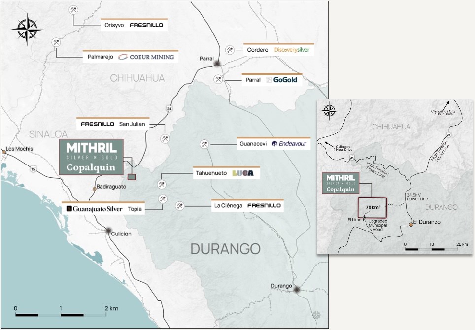
Figure 1 Copalquin District location map, locations of mining and exploration activity and local infrastructure.
To view an enhanced version of this graphic, please visit:
https://images.newsfilecorp.com/files/11657/269787_376ac90bf45b1a08_001full.jpg
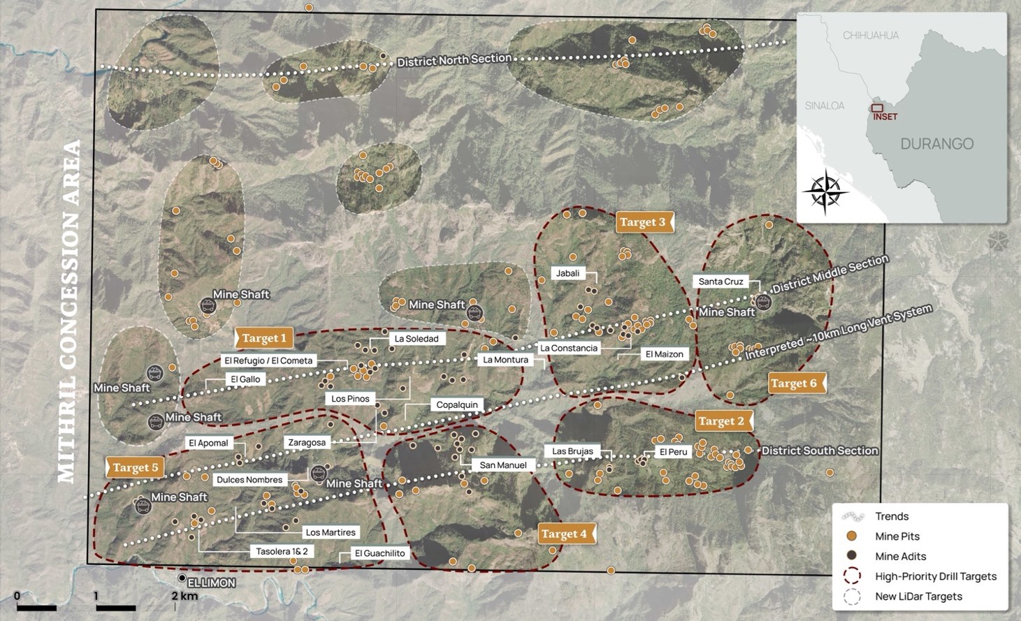
Figure 2 LiDAR identified historic workings across the 70km2 district. Current drilling locations at Target 1 west and Target 5 (El Apomal), and recent drilling at Zaragoza mine in Target 1 south, high priority drill target area of La Constancia-El Jabali (Target 3). Several new areas highlighted across the district for follow-up work including recently sampled Target 6
To view an enhanced version of this graphic, please visit:
https://images.newsfilecorp.com/files/11657/269787_376ac90bf45b1a08_002full.jpg
Copalquin District Exploration Progress Update
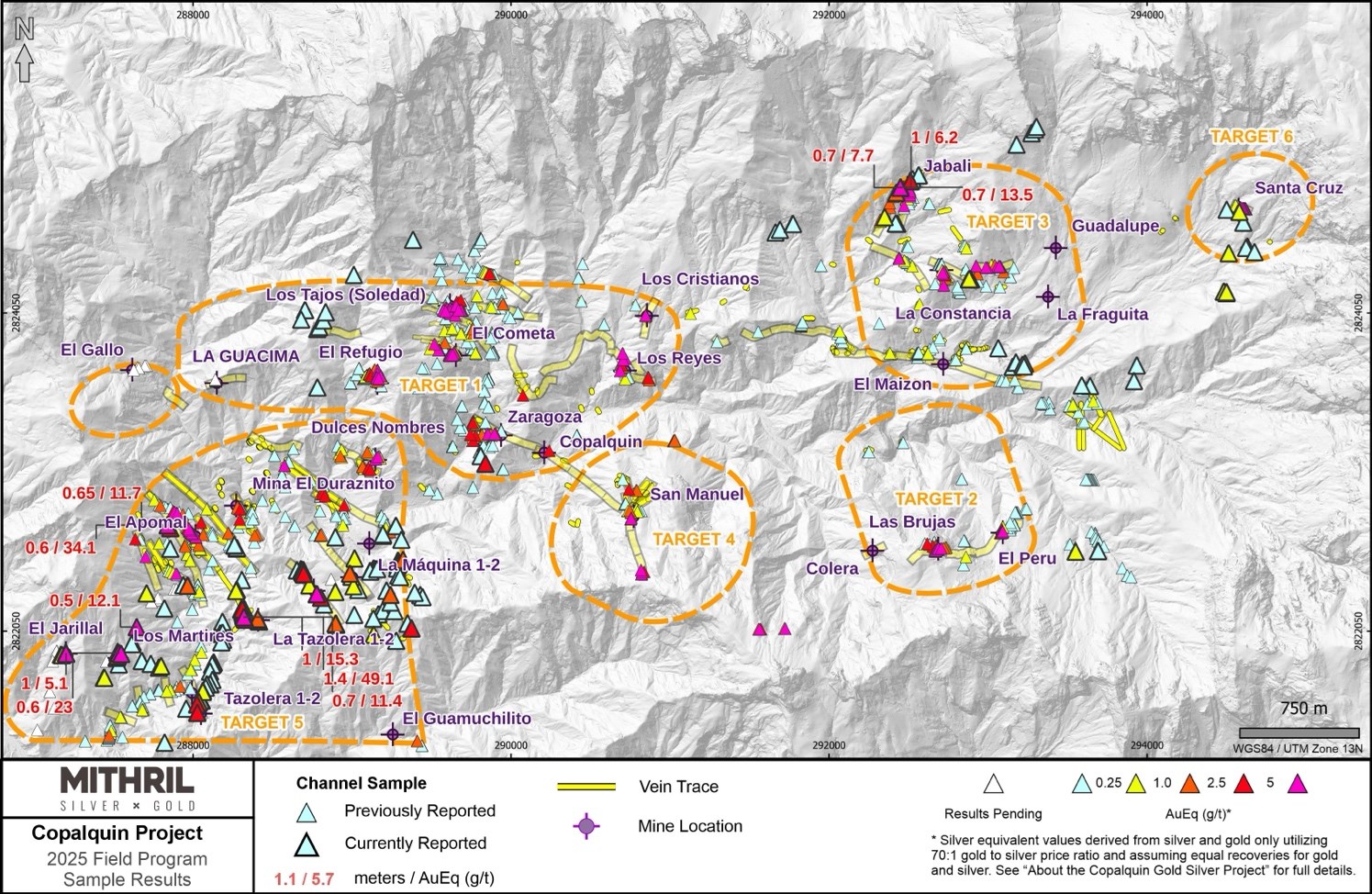
Figure 3 Property-wide channel sampling results for the middle and south district sections within ~50% of the 70 km2 mining concession area covering the Copalquin District
To view an enhanced version of this graphic, please visit:
https://images.newsfilecorp.com/files/11657/269787_376ac90bf45b1a08_003full.jpg
Underground samples at Target 5 over 100 g/t silver Eq:
- 3.1 m @ 2.02 g/t gold, 1,938 g/t silver (Tasolera Mine Level 2),
- including 1.40 m @ 2.00 g/t gold, 3,300 g/t silver
- 1.0 m @ 0.863 g/t gold, 210 g/t silver (Tasolera Mine Level 2)
- 1.0 m @ 0.542 g/t gold, 96.6 g/t silver (Tasolera Mine Level 3)
- 1.0 m @ 0.322 g/t gold, 79.9 g/t silver (Tasolera Mine Level 3)
- 0.5 m @ 0.603 g/t gold, 154 g/t silver (Las Lianas)
- 0.6 m @ 10.25 g/t gold, 895 g/t silver (Los Martires)
- 0.8 m @ 1.72 g/t gold, 191 g/t silver (Los Martires)
- 0.9 m @ 3.31 g/t gold, 219 g/t silver (Los Martires)
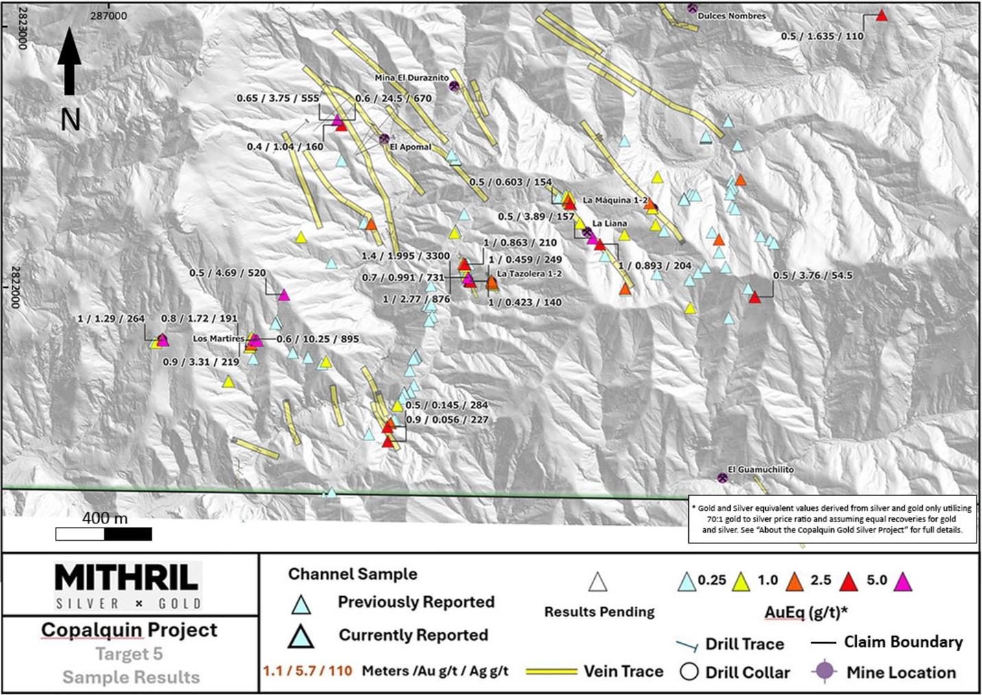
Figure 4 Target 5 new channel sample assay results. First 9 drill holes have been completed in the northern part of this large target area (assays pending)
To view an enhanced version of this graphic, please visit:
https://images.newsfilecorp.com/files/11657/269787_376ac90bf45b1a08_004full.jpg
Surface samples at Target 5 over 100 g/t silver Eq:
- 0.5 m @ 3.89 g/t gold, 157 g/t silver (La Candelaria)
- 1.0 m @ 0.893 g/t gold, 204 g/t silver (La Candelaria)
- 0.6 m @ 0.39 g/t gold, 92.9 g/t silver (La Candelaria)
- 0.7 m @ 0.914 g/t gold, 50.9 g/t silver (Las Lianas)
- 0.3 m @ 1.275 g/t gold, 61.9 g/t silver (La Tasolera)
- 0.5 m @ 0.476 g/t gold, 68.7 g/t silver (La Tasolera)
- 0.5 m @ 0.145 g/t gold, 284 g/t silver (La Tasolera)
- 0.9 m @ 0.056 g/t gold, 227 g/t silver (La Tasolera)
- 1.0 m @ 0.076 g/t , 108 g/t silver (Cementerio el Limon)
- 0.5 m @ 0.323 g/t gold, 101 g/t silver (Candelaria)
- 0.5 m @ 3.76 g/t gold, 54.5 g/t silver (Candelaria)
- 0.4 m @ 1.04 g/t gold, 160 g/t silver (Apomal)
- 0.65 m @ 3.75 g/t gold, 555 g/t silver (Apomal)
- 0.6 m @ 24.5 g/t gold, 670 g/t silver (Apomal)
- 1.0 m @ 0.423 g/t gold, 140 g/t silver (Tasolera Level 2)
- 1.00 m @ 0.162 g/t gold, 129 g/t silver (Tasolera Level 2)
- 1.00 m @ 0.459 g/t gold, 249 g/t silver (Tasolera Level 2)
- 1.00 m @ 1.29 g/t gold, 264 g/t silver (El Jarillal)
- 1.10 m @ 0.492 g/t gold, 67.3 g/t silver (El Jarillal)
- 0.50 m @ 4.69 g/t gold, 520 g/t silver (Los Martires)
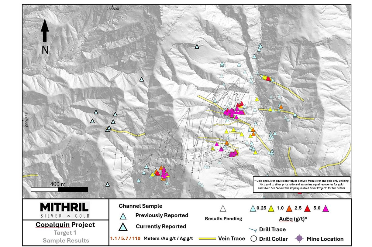
Figure 5 Target 1 channel sample results with anomalous values extending the to west
To view an enhanced version of this graphic, please visit:
https://images.newsfilecorp.com/files/11657/269787_376ac90bf45b1a08_005full.jpg
Underground and surface samples at Targets 1 and 3 over 1 g/t Au Eq:
- 0.5 m @ 1.635 g/t gold, 110 g/t silver (Cementerio El Limon; Target 1; Surface)
- 0.7 m @ 8.81 g/t gold, 329 g/t silver (Jabali Level 3; Target 3; Underground)
- 1.0 m @ 3.42 g/t gold, 194 g/t silver (Jabali Level 3; Target 3; Underground)
- 0.7 m @ 5.16 g/t gold, 176 g/t silver (Jabali Level 3; Target 3; Underground)
- 0.6 m @ 1.225 g/t gold, 5.7 g/t silver (South Jabali; Target 3; Surface)
- 0.5 m @ 2.18 g/t gold, 100 g/t silver (North Jabali; Target 3; Surface)
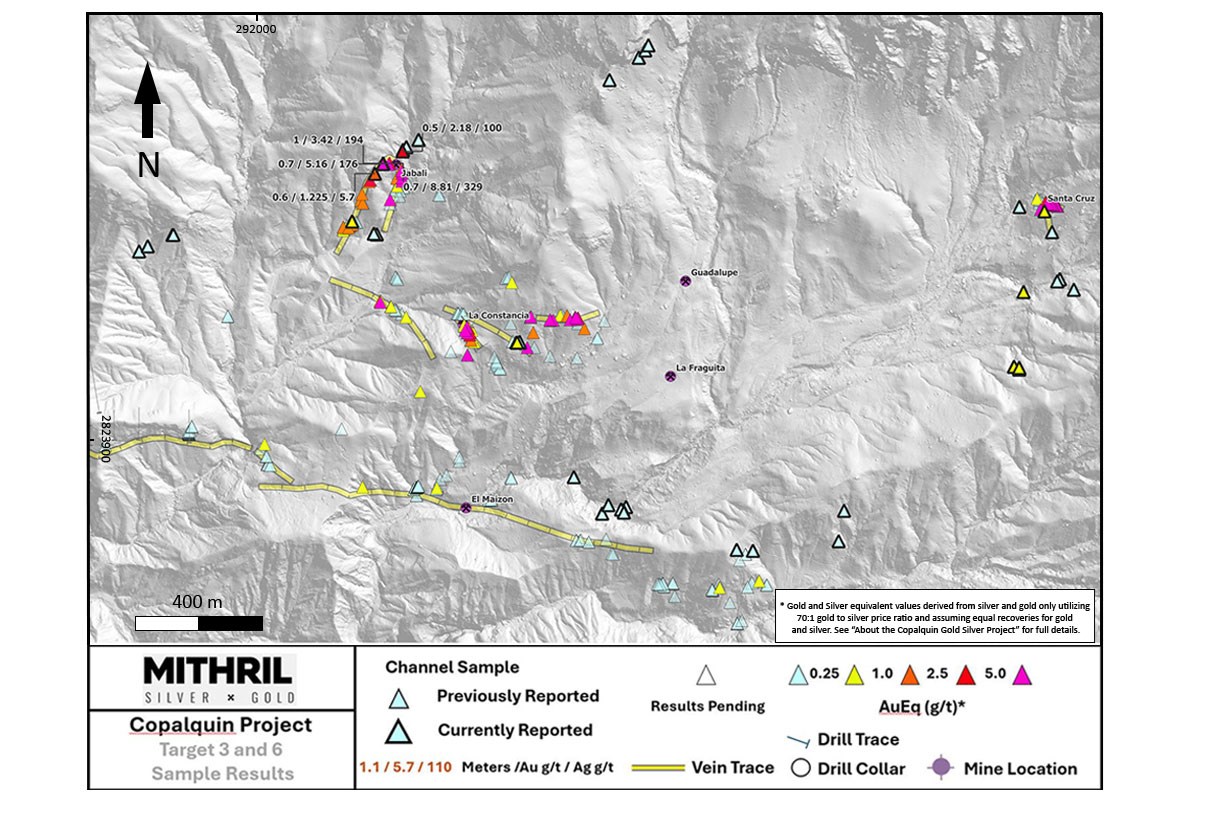
Figure 6 Targets 3 and 6 areas with new channel sample assay results for Target 3 area which is being prepared for maiden drill program via addition of a third drill rig
To view an enhanced version of this graphic, please visit:
https://images.newsfilecorp.com/files/11657/269787_376ac90bf45b1a08_006full.jpg
Drilling at Target 5 has commenced, focusing on numerous northwest-trending vein systems, including those at the historic Apomal Mine. To date, nine drill holes have been successfully completed with assays pending. Early indications from the program are encouraging which, coupled with the widespread high-grade surface and historic mine samples, support the potential for a significant area of mineralisation in this highly prospective zone at a lower elevation in the district.
ABOUT THE COPALQUIN GOLD SILVER PROJECT
The Copalquin mining district is located in Durango State, Mexico and covers an entire mining district of 70km2 containing several dozen historic gold and silver mines and workings, ten of which had notable production. The district is within the Sierra Madre Gold Silver Trend which extends north-south along the western side of Mexico and hosts many gold and silver districts.
Multiple mineralisation events, young intrusives thought to be system-driving heat sources, widespread alteration together with extensive surface vein exposures and dozens of historic mine workings, identify the Copalquin mining district as a major epithermal centre for Gold and Silver.
Within 15 months of drilling in the Copalquin District, Mithril delivered a maiden JORC mineral resource estimate demonstrating the high-grade gold and silver resource potential for the district. This maiden resource is detailed below (see ASX release 17 November 2021)^ and a NI 43-101 Technical Report filed on SEDAR+
- Indicated 691 kt @ 5.43 g/t gold, 114 g/t silver for 121,000 oz gold plus 2,538,000 oz silver
- Inferred 1,725 kt @ 4.55 g/t gold, 152 g/t silver for 252,000 oz gold plus 8,414,000 oz silver
(using a cut-off grade of 2.0 g/t AuEq*)
- 28.6% of the resource tonnage is classified as indicated
Table 1 Mineral resource estimate El Refugio – La Soledad using a cut-off grade of 2.0 g/t AuEq*
| Tonnes (kt) |
Tonnes (kt) |
Gold (g/t) |
Silver (g/t) |
Gold Eq.* (g/t) | Gold (koz) |
Silver (koz) |
Gold Eq.* (koz) | |
| El Refugio | Indicated | 691 | 5.43 | 114.2 | 7.06 | 121 | 2,538 | 157 |
| Inferred | 1,447 | 4.63 | 137.1 | 6.59 | 215 | 6,377 | 307 | |
| La Soledad | Indicated | – | – | – | – | – | – | – |
| Inferred | 278 | 4.12 | 228.2 | 7.38 | 37 | 2,037 | 66 | |
| Total | Indicated | 691 | 5.43 | 114.2 | 7.06 | 121 | 2,538 | 157 |
| Inferred | 1,725 | 4.55 | 151.7 | 6.72 | 252 | 8,414 | 372 |
* In determining the gold equivalent (AuEq.) grade for reporting, a gold:silver price ratio of 70:1 was determined, using the formula: AuEq grade = Au grade + ((silver grade/70) x (silver recovery/Au recovery)). The metal prices used to determine the 70:1 ratio are the cumulative average prices for 2021: gold USD1,798.34 and silver: USD25.32 (actual is 71:1) from kitco.com. At this early stage, the metallurgical recoveries were assumed to be equal (93%). Subsequent preliminary metallurgical test work produced recoveries of 91% for silver and 96% for gold (ASX Announcement 25 February 2022) and these will be used when the resource is updated in the future. In the Company’s opinion there is reasonable potential for both gold and silver to be extracted and sold.
^ The information in this report that relates to Mineral Resources or Ore Reserves is based on information provided in the following ASX announcement: 17 Nov 2021 – MAIDEN JORC RESOURCE 529,000 OUNCES @ 6.81G/T (AuEq*), which includes the full JORC MRE report, also available on the Mithril Resources Limited Website.
The Company confirms that it is not aware of any new information or data that materially affects the information included in the original market announcement and that all material assumptions and technical parameters underpinning the estimates in the relevant market announcement continue to apply and have not materially changed. The company confirms that the form and context in which the Competent Person’s findings are presented have not been materially modified from the original market announcement.
Mining study (conceptual) and metallurgical test work supports the development of the El Refugio-La Soledad resource with conventional underground mining methods indicated as being appropriate and with high gold-silver recovery to produce metal on-site with conventional processing.
Mithril is currently exploring in the Copalquin District to expand the resource footprint, demonstrating its multi-million-ounce gold and silver potential. Mithril has an exclusive option to purchase 100% interest in the Copalquin mining concessions by paying US$10M on or any time before 7 August 2028.
-ENDS-
Released with the authority of the Board.
For further information contact:
| John Skeet Managing Director and CEO jskeet@mithrilsilvergold.com +61 435 766 809 |
NIKLI COMMUNICATIONS Corporate Communications liz@mithrilsilvergold.com nicole@mithrilsilvergold.com |
The Australian Securities Exchange has not reviewed and does not accept responsibility for the accuracy or adequacy of this release.
Neither TSX Venture Exchange nor its Regulation Services Provider (as that term is defined in policies of the TSX Venture Exchange) accepts responsibility for the adequacy or accuracy of this release.
Competent Persons Statement – JORC
The information in this announcement that relates to metallurgical test results, mineral processing and project development and study work has been compiled by Mr John Skeet who is Mithril’s CEO and Managing Director. Mr Skeet is a Fellow of the Australasian Institute of Mining and Metallurgy. This is a Recognised Professional Organisation (RPO) under the Joint Ore Reserves Committee (JORC) Code.
Mr Skeet has sufficient experience of relevance to the styles of mineralisation and the types of deposits under consideration, and to the activities undertaken, to qualify as a Competent Person as defined in the 2012 Edition of the Joint Ore Reserves Committee (JORC) Australasian Code for Reporting of Exploration Results, Mineral Resources and Ore Reserves. Mr Skeet consents to the inclusion in this report of the matters based on information in the form and context in which it appears. The Australian Securities Exchange has not reviewed and does not accept responsibility for the accuracy or adequacy of this release.
The information in this announcement that relates to sampling techniques and data, exploration results and geological interpretation for Mithril’s Mexican project, has been compiled by Mr Patrick Loury who is Mithril’s Project Consultant. Mr Loury is a member of the American Institute of Professional Geologists and a Certified Professional Geologist (CPG). This is a Recognised Professional Organisation (RPO) under the Joint Ore Reserves Committee (JORC) Code.
Mr Loury has sufficient experience of relevance to the styles of mineralisation and the types of deposits under consideration, and to the activities undertaken, to qualify as a Competent Person as defined in the 2012 Edition of the Joint Ore Reserves Committee (JORC) Australasian Code for Reporting of Exploration Results, Mineral Resources and Ore Reserves. Mr Loury consents to the inclusion in this report of the matters based on information in the form and context in which it appears.
The information in this announcement that relates to Mineral Resources is reported by Mr Rodney Webster, Principal Geologist at AMC Consultants Pty Ltd (AMC), who is a Member of the Australasian Institute of Mining and Metallurgy. The report was peer reviewed by Andrew Proudman, Principal Consultant at AMC. Mr Webster is acting as the Competent Person, as defined in the 2012 Edition of the Joint Ore Reserves Committee (JORC) Australasian Code for Reporting of Exploration Results, Mineral Resources and Ore Reserves, for the reporting of the Mineral Resource estimate. A site visit was carried out by Jose Olmedo a geological consultant with AMC, in September 2021 to observe the drilling, logging, sampling and assay database. Mr Webster consents to the inclusion in this report of the matters based on information in the form and context in which it appears
Qualified Persons – NI 43-101
Scientific and technical information in this Report has been reviewed and approved by Mr John Skeet (FAUSIMM, CP) Mithril’s Managing Director and Chief Executive Officer. Mr John Skeet is a qualified person within the meaning of NI 43-101.
Samples are sent to ALS Global with sample preparation performed in Chihuahua City, Mexico and assaying of sample pulps performed in North Vancouver, BC, Canada.
Table 2 Full list of channel sample details and assays
| Sample | Easting (m) |
Northing (m) |
Elev (m) |
Surface/UG | Target | Location | Width (m) | Sample Direction (deg) |
Sample Incl. (deg) |
Au (g/t) | silver (g/t) |
Cu (g/t) |
Pb (g/t) |
Zn (g/t) |
| 814262 | 288698.90 | 2822407.80 | 775 | UNDERGROUND | 5 | Mina Las Lianas | 0.50 | 245 | 7 | 0.013 | 1.8 | 73 | 58 | 237 |
| 814263 | 288698.51 | 2822407.48 | 775 | UNDERGROUND | 5 | Mina Las Lianas | 0.50 | 245 | 3 | 0.038 | 3 | 14 | 268 | 641 |
| 814264 | 288696.33 | 2822410.87 | 775 | UNDERGROUND | 5 | Mina Las Lianas | 0.50 | 240 | 6 | 0.412 | 64.8 | 33 | 147 | 193 |
| 814265 | 288695.94 | 2822410.55 | 775 | UNDERGROUND | 5 | Mina Las Lianas | 0.50 | 240 | 60 | 0.168 | 28.9 | 14 | 116 | 305 |
| 814266 | 288695.56 | 2822410.22 | 775 | UNDERGROUND | 5 | Mina Las Lianas | 0.50 | 240 | 70 | 0.603 | 154 | 23 | 265 | 533 |
| 814268 | 288693.76 | 2822413.93 | 775 | UNDERGROUND | 5 | Mina Las Lianas | 0.60 | 220 | 2 | 0.01 | 1 | 16 | 19 | 111 |
| 814269 | 288693.22 | 2822413.48 | 775 | UNDERGROUND | 5 | Mina Las Lianas | 0.50 | 220 | 2 | 0.357 | 40.6 | 16 | 126 | 154 |
| 814270 | 288692.68 | 2822413.03 | 775 | UNDERGROUND | 5 | Mina Las Lianas | 0.50 | 220 | 2 | 0.216 | 19.2 | 46 | 100 | 144 |
| 814271 | 288690.20 | 2822416.50 | 775 | SURFACE | 5 | LA CANDELARIA | 0.50 | 50 | 15 | 0.161 | 22.8 | 32 | 60 | 143 |
| 814272 | 288686.71 | 2822422.47 | 817 | SURFACE | 5 | LA CANDELARIA | 0.80 | 40 | 45 | 0.164 | 24 | 16 | 24 | 63 |
| 814273 | 288687.36 | 2822423.23 | 817 | SURFACE | 5 | LA CANDELARIA | 1.00 | 40 | 35 | 0.009 | 2.1 | 8 | 18 | 88 |
| 814274 | 288688.00 | 2822424.00 | 818 | SURFACE | 5 | LA CANDELARIA | 1.00 | 40 | 35 | 0.005 | 0.5 | 7 | 13 | 72 |
| 814276 | 288688.64 | 2822424.77 | 818 | SURFACE | 5 | LA CANDELARIA | 1.00 | 40 | 30 | 0.018 | 3.1 | 18 | 12 | 104 |
| 814277 | 288689.29 | 2822425.53 | 818 | SURFACE | 5 | LA CANDELARIA | 0.50 | 40 | 25 | 0.343 | 67.1 | 16 | 44 | 116 |
| 814278 | 288689.61 | 2822425.92 | 818 | SURFACE | 5 | LA CANDELARIA | 1.00 | 40 | 25 | 0.108 | 17.8 | 9 | 50 | 123 |
| 814279 | 288690.25 | 2822426.68 | 819 | SURFACE | 5 | LA CANDELARIA | 0.50 | 40 | 15 | 0.005 | 0.5 | 33 | 16 | 74 |
| 814280 | 288690.57 | 2822427.06 | 819 | SURFACE | 5 | LA CANDELARIA | 0.50 | 40 | 15 | 0.017 | 2.5 | 22 | 73 | 159 |
| 814281 | 288690.89 | 2822427.45 | 819 | SURFACE | 5 | LA CANDELARIA | 1.00 | 40 | 20 | 0.005 | 0.5 | 14 | 13 | 74 |
| 814283 | 288691.54 | 2822428.21 | 820 | SURFACE | 5 | LA CANDELARIA | 1.00 | 40 | 10 | 0.005 | 0.5 | 10 | 11 | 106 |
| 814284 | 288692.24 | 2822429.06 | 820 | SURFACE | 5 | LA CANDELARIA | 1.00 | 40 | 15 | 0.005 | 1 | 25 | 74 | 111 |
| 814285 | 288692.82 | 2822429.75 | 820 | SURFACE | 5 | LA CANDELARIA | 1.00 | 40 | 10 | 0.008 | 1.4 | 19 | 153 | 89 |
| 814286 | 288693.46 | 2822430.51 | 821 | SURFACE | 5 | LA CANDELARIA | 0.50 | 40 | 15 | 0.194 | 31.4 | 13 | 108 | 111 |
| 814287 | 288678.11 | 2822441.15 | 821 | SURFACE | 5 | LA CANDELARIA | 0.70 | 60 | 5 | 0.052 | 7.5 | 23 | 22 | 78 |
| 814288 | 288682.61 | 2822438.35 | 824 | SURFACE | 5 | LA CANDELARIA | 0.75 | 45 | 5 | 0.111 | 14.8 | 25 | 61 | 58 |
| 814289 | 288693.49 | 2822435.49 | 826 | SURFACE | 5 | LA CANDELARIA | 0.70 | 50 | 5 | 0.228 | 11.7 | 29 | 193 | 94 |
| 814290 | 288731.25 | 2822339.57 | 867 | SURFACE | 5 | LA CANDELARIA | 0.50 | 150 | 70 | 0.214 | 14.1 | 7 | 39 | 9 |
| 814291 | 288779.26 | 2822284.48 | 880 | SURFACE | 5 | LA CANDELARIA | 0.90 | 235 | 3 | 0.383 | 3 | 17 | 164 | 86 |
| 814292 | 288778.85 | 2822284.20 | 880 | SURFACE | 5 | LA CANDELARIA | 0.50 | 235 | 3 | 3.89 | 157 | 40 | 962 | 102 |
| 814293 | 288778.12 | 2822283.68 | 880 | SURFACE | 5 | LA CANDELARIA | 0.90 | 235 | 5 | 0.6 | 9.3 | 41 | 626 | 155 |
| 814294 | 288805.36 | 2822262.23 | 885 | SURFACE | 5 | LA CANDELARIA | 1.00 | 220 | 20 | 0.893 | 204 | 17 | 114 | 167 |
| 814295 | 288823.75 | 2822219.57 | 876 | SURFACE | 5 | LA CANDELARIA | 0.50 | 210 | 65 | 0.042 | 2.3 | 15 | 50 | 123 |
| 814296 | 288898.54 | 2822099.61 | 940 | SURFACE | 5 | LA CANDELARIA | 0.60 | 230 | 7 | 0.39 | 92.9 | 37 | 1125 | 366 |
| 814297 | 288898.00 | 2822099.16 | 940 | SURFACE | 5 | LA CANDELARIA | 0.70 | 230 | 7 | 0.029 | 9.2 | 26 | 62 | 916 |
| 814298 | 288897.24 | 2822098.52 | 940 | SURFACE | 5 | LA CANDELARIA | 1.00 | 250 | 11 | 0.075 | 15.3 | 23 | 147 | 577 |
| 814299 | 288896.63 | 2822098.01 | 940 | SURFACE | 5 | LA CANDELARIA | 0.80 | 250 | 11 | 0.317 | 49.7 | 30 | 572 | 300 |
| 814301 | 288900.48 | 2822092.53 | 952 | SURFACE | 5 | LA CANDELARIA | 0.70 | 228 | 25 | 0.122 | 7.1 | 37 | 566 | 391 |
| 814302 | 289014.51 | 2822153.51 | 926 | SURFACE | 5 | LA CANDELARIA | 0.70 | 225 | 3 | 0.208 | 1.6 | 21 | 48 | 71 |
| 814303 | 288894.66 | 2822297.76 | 870 | SURFACE | 5 | LA CANDELARIA | 0.80 | 110 | 7 | 0.109 | 41.5 | 73 | 18450 | 3560 |
| 814304 | 289276.00 | 2822714.00 | 835 | Surface | 5 | 0.50 | 205 | 28 | 0.006 | 0.5 | 79 | 244 | 154 | |
| 814305 | 289276.00 | 2822713.50 | 835 | Surface | 5 | 0.50 | 205 | 28 | 0.01 | 0.7 | 52 | 72 | 86 | |
| 814308 | 289310.00 | 2822626.00 | 823 | Surface | 5 | 0.70 | 90 | 0.023 | 3.8 | 33 | 96 | 100 | ||
| 814309 | 289289.00 | 2822495.00 | 863 | Surface | 5 | 0.60 | 240 | 0 | 0.017 | 3.6 | 51 | 106 | 115 | |
| 814310 | 289293.00 | 2822478.00 | 861 | Surface | 5 | 0.50 | 30 | 0 | 0.018 | 1.9 | 40 | 91 | 168 | |
| 814311 | 289291.00 | 2822473.00 | 862 | Surface | 5 | 0.70 | 180 | 0 | 0.017 | 3.9 | 50 | 172 | 233 | |
| 814313 | 289286.00 | 2822465.00 | 861 | Surface | 5 | 0.50 | 190 | 0 | 0.039 | 4.4 | 33 | 181 | 123 | |
| 814314 | 289283.00 | 2822446.00 | 859 | Surface | 5 | 1.00 | 205 | 0 | 0.037 | 1.1 | 26 | 72 | 166 | |
| 814315 | 289135.00 | 2822445.00 | 887 | Surface | 5 | 1.00 | 60 | 0 | 0.009 | 0.8 | 25 | 39 | 551 | |
| 814316 | 289146.00 | 2822442.00 | 882 | Surface | 5 | 0.50 | 260 | 0 | 0.011 | 0.7 | 9 | 124 | 157 | |
| 814317 | 289114.00 | 2822430.00 | 885 | Surface | 5 | 0.50 | 205 | 0 | 0.02 | 2.3 | 75 | 2350 | 146 | |
| 814318 | 289114.00 | 2822429.50 | 885 | Surface | 5 | 1.00 | 205 | 0 | 0.056 | 7.1 | 87 | 3060 | 266 | |
| 814319 | 289114.00 | 2822426.00 | 885 | Surface | 5 | 0.50 | 205 | 0 | 0.036 | 1.2 | 19 | 60 | 111 | |
| 814320 | 288987.00 | 2822413.00 | 884 | Surface | 5 | 0.70 | 270 | 0 | 0.914 | 50.9 | 13 | 92 | 99 | |
| 814321 | 288998.00 | 2822395.00 | 895 | Surface | 5 | 0.80 | 235 | 0 | 0.011 | 2.2 | 26 | 46 | 179 | |
| 814322 | 288997.50 | 2822394.50 | 895 | Surface | 5 | 1.00 | 235 | 0 | 0.116 | 21.9 | 49 | 1865 | 179 | |
| 814323 | 288997.00 | 2822394.00 | 895 | Surface | 5 | 0.50 | 295 | 0 | 0.016 | 2.5 | 34 | 77 | 239 | |
| 814324 | 289193.00 | 2822651.00 | 785 | Surface | 5 | 0.60 | 0 | 0 | 0.026 | 3.8 | 180 | 546 | 173 | |
| 814326 | 289194.00 | 2822652.00 | 785 | Surface | 5 | 0.50 | 350 | 0 | 0.015 | 2.9 | 195 | 597 | 310 | |
| 814327 | 289194.00 | 2822655.00 | 785 | Surface | 5 | 0.80 | 5 | 0 | 0.007 | 1.5 | 69 | 421 | 308 | |
| 814328 | 289194.00 | 2822655.80 | 785 | Surface | 5 | 0.20 | 340 | 0 | 0.015 | 2.6 | 56 | 400 | 195 | |
| 814329 | 289194.00 | 2822656.00 | 785 | Surface | 5 | 0.90 | 30 | 0 | 0.012 | 2.5 | 120 | 236 | 514 | |
| 814330 | 289194.00 | 2822657.00 | 785 | Surface | 5 | 0.50 | 15 | 0 | 0.012 | 1.7 | 85 | 198 | 291 | |
| 814331 | 289194.00 | 2822659.00 | 785 | Surface | 5 | 0.50 | 355 | 0 | 0.009 | 1.8 | 223 | 132 | 1760 | |
| 814332 | 289194.00 | 2822659.50 | 785 | Surface | 5 | 0.90 | 35 | 0 | 0.006 | 6.5 | 237 | 222 | 733 | |
| 814333 | 289321.00 | 2822500.00 | 869 | Surface | 5 | 0.80 | 180 | 0 | 0.392 | 68.3 | 37 | 157 | 150 | |
| 814334 | 289158.00 | 2822441.00 | Surface | 5 | 0.70 | 315 | 0 | 0.036 | 3.4 | 28 | 82 | 129 | ||
| 814335 | 289383.00 | 2824511.00 | 1277 | Surface | 5 | 45 | 0 | 0.005 | 0.5 | 8 | 17 | 18 | ||
| 814336 | 289016.00 | 2822509.00 | 821 | Surface | 5 | 0.75 | 245 | 0 | 0.1 | 13.2 | 355 | 523 | 203 | |
| 814337 | 288895.00 | 2822642.00 | 870 | Surface | 5 | 0.60 | 205 | 0 | 0.018 | 9 | 135 | 211 | 629 | |
| 814338 | 288653.00 | 2822434.00 | 793 | Surface | 5 | 0.50 | 75 | 0 | 0.009 | 0.7 | 56 | 122 | 195 | |
| 814621 | 292879.25 | 2824263.44 | 1506.94 | Surface | 3 | Constancia | 1.00 | 0 | 44 | 0.044 | 1.1 | 12 | 65 | 17 |
| 814622 | 292881.18 | 2824263.96 | 1504.87 | Surface | 3 | Constancia | 0.70 | 350 | 50 | 0.122 | 10 | 12 | 424 | 11 |
| 814623 | 292888.30 | 2824263.49 | 1504.9 | Surface | 3 | Constancia | 0.60 | 345 | 22 | 0.022 | 1.3 | 8 | 15 | 9 |
| 814624 | 292890.09 | 2824263.29 | 1497.64 | Surface | 3 | Constancia | 0.80 | 340 | 22 | 0.047 | 2.1 | 9 | 62 | 11 |
| 814626 | 292889.48 | 2824266.06 | 1498.15 | Surface | 3 | Constancia | 0.60 | 220 | 70 | 0.012 | 0.9 | 6 | 17 | 5 |
| 814627 | 292428.30 | 2824612.28 | 1352.6 | Surface | 3 | Constancia | 0.60 | 65 | 60 | 0.039 | 7.8 | 13 | 67 | 28 |
| 814628 | 292427.71 | 2824611.13 | 1352.6 | Surface | 3 | Constancia | 1.00 | 65 | 0 | 0.038 | 5 | 9 | 42 | 37 |
| 814629 | 292419.08 | 2824614.64 | 1346.36 | Surface | 3 | Constancia | 0.50 | 75 | 50 | 0.01 | 1.4 | 6 | 10 | 32 |
| 814630 | 294481.57 | 2824185.68 | 1733.86 | Surface | 6 | Sur Santa Cruz | 1.00 | 60 | 0 | 0.354 | 24.8 | 8 | 16 | 30 |
| 814632 | 294482.70 | 2824185.67 | 1733.86 | Surface | 6 | Sur Santa Cruz | 0.75 | 100 | 45 | 0.382 | 18.3 | 19 | 15 | 10 |
| 814633 | 294499.13 | 2824176.27 | 1747.58 | Surface | 6 | Sur Santa Cruz | 1.00 | 0 | 26 | 0.04 | 4.3 | 10 | 19 | 17 |
| 814634 | 294499.11 | 2824177.39 | 1748.08 | Surface | 6 | Sur Santa Cruz | 1.00 | 0 | 26 | 0.085 | 6 | 4 | 19 | 19 |
| 814635 | 294499.10 | 2824178.46 | 1748.58 | Surface | 6 | Sur Santa Cruz | 1.00 | 0 | 26 | 0.05 | 4.3 | 8 | 16 | 66 |
| 814636 | 294499.08 | 2824179.56 | 1749.08 | Surface | 6 | Sur Santa Cruz | 1.00 | 0 | 26 | 0.138 | 5 | 12 | 18 | 52 |
| 814637 | 294499.24 | 2824180.61 | 1749.58 | Surface | 6 | Sur Santa Cruz | 1.00 | 0 | 26 | 0.117 | 2.2 | 8 | 7 | 14 |
| 814638 | 294499.30 | 2824181.65 | 1750.08 | Surface | 6 | Sur Santa Cruz | 1.00 | 0 | 26 | 0.079 | 1.9 | 12 | 11 | 21 |
| 814639 | 294499.35 | 2824182.66 | 1750.58 | Surface | 6 | Sur Santa Cruz | 1.00 | 0 | 26 | 0.207 | 4.2 | 19 | 13 | 53 |
| 814640 | 294499.43 | 2824183.71 | 1751.08 | Surface | 6 | Sur Santa Cruz | 1.00 | 0 | 26 | 0.058 | 5 | 30 | 11 | 21 |
| 814642 | 292449.89 | 2824840.74 | 1505.83 | Underground | 3 | Jabali 3 workings | 0.70 | 310 | 0 | 8.81 | 329 | 66 | 97 | 67 |
| 814643 | 292450.66 | 2824840.18 | 1505.23 | Underground | 3 | Jabali 3 workings | 1.00 | 310 | 65 | 3.42 | 194 | 22 | 31 | 71 |
| 814644 | 292448.54 | 2824839.14 | 1505.83 | Underground | 3 | Jabali 3 workings | 0.70 | 310 | 0 | 5.16 | 176 | 52 | 54 | 92 |
| 814645 | 292422.99 | 2824807.94 | 1488.95 | Surface | 3 | South Jabali 3 | 0.60 | 280 | 0 | 1.225 | 5.7 | 4 | 15 | 60 |
| 814646 | 292348.85 | 2824653.93 | 1375.97 | Underground | 3 | El Chinacate 3 | 1.00 | 60 | 0 | 0.599 | 23.6 | 4 | 2 | 5 |
| 814592 | 293064 | 2823830 | 1246 | Surface | 3 | Los Riscos S | 0.50 | 340 | 0 | 0.007 | 0.5 | 36 | 13 | 91 |
| 814593 | 293155 | 2823713 | 1379 | Surface | 3 | Los Riscos S | 1.00 | 170 | -80 | 0.006 | 0.6 | 11 | 3 | 11 |
| 814594 | 293155 | 2823713 | 1379 | Surface | 3 | Los Riscos S | 1.00 | 170 | -80 | 0.013 | 1 | 19 | 4 | 23 |
| 814595 | 293155 | 2823713 | 1379 | Surface | 3 | Los Riscos S | 1.00 | 170 | -80 | 0.012 | 0.5 | 20 | 3 | 24 |
| 814596 | 293175 | 2823740 | 1378 | Surface | 3 | Los Riscos S | 0.80 | 40 | -70 | 0.006 | 0.6 | 19 | 4 | 38 |
| 814597 | 293175 | 2823740 | 1378 | Surface | 3 | Los Riscos S | 0.50 | 40 | -70 | 0.019 | 0.5 | 21 | 6 | 50 |
| 814598 | 293232 | 2823734 | 1386 | Surface | 3 | Los Riscos S | 0.50 | 55 | 0 | 0.035 | 3.3 | 39 | 37 | 97 |
| 814599 | 293223 | 2823724 | 1385 | Surface | 3 | Los Riscos S | 0.80 | 65 | -85 | 0.017 | 2.5 | 33 | 17 | 98 |
| 814701 | 293216 | 2823726 | 1386 | Surface | 3 | Los Riscos S | 0.50 | 50 | -85 | 0.005 | 0.7 | 37 | 8 | 87 |
| 814702 | 293225 | 2823716 | 1393 | Surface | 3 | Los Riscos S | 0.80 | 60 | -75 | 0.093 | 6.2 | 67 | 45 | 72 |
| 814703 | 293691 | 2822554 | 1534 | Surface | 2 | El Peru E | 1.00 | 50 | 0 | 0.005 | 0.5 | 8 | 20 | 36 |
| 814704 | 293692 | 2822555 | 1534 | Surface | 2 | El Peru E | 1.00 | 350 | -25 | 0.005 | 0.5 | 11 | 15 | 31 |
| 814705 | 293550 | 2822551 | 1568 | Surface | 2 | El Peru E | 1.00 | 75 | -15 | 0.83 | 7.2 | 4 | 11 | 11 |
| 814706 | 293641 | 2823593 | 1503 | Surface | 2 | El Peru Camp | 0.50 | 175 | -45 | 0.01 | 0.5 | 49 | 14 | 89 |
| 814707 | 293935 | 2823722 | 1647 | Surface | 2 | El Peru N | 0.50 | 240 | -10 | 0.005 | 0.5 | 66 | 14 | 92 |
| 814708 | 293917 | 2823624 | 1582 | Surface | 2 | El Peru N | 0.50 | 145 | 0 | 0.005 | 0.5 | 17 | 16 | 54 |
| 814709 | 293589 | 2823596 | 1540 | Surface | 2 | El Peru N | 0.50 | 260 | -15 | 0.005 | 0.5 | 25 | 3 | 49 |
| 814339 | 288704.00 | 2824070.00 | 1217 | Surface | 1 | Refugio West | 0.75 | 35 | 90 | 0.007 | 0.5 | 31 | 11 | 86 |
| 814340 | 288703.57 | 2824069.39 | 1217 | Surface | 1 | Refugio West | 0.75 | 35 | 90 | 0.005 | 0.5 | 45 | 14 | 89 |
| 814341 | 288680.00 | 2824010.00 | 1207 | Surface | 1 | Refugio West | 0.90 | 100 | 90 | 0.005 | 0.5 | 35 | 10 | 100 |
| 814343 | 288782.00 | 2823951.00 | 1121 | Surface | 1 | Refugio West | 1.00 | 280 | 0 | 0.006 | 0.5 | 65 | 10 | 93 |
| 814344 | 288793.00 | 2823964.00 | 1156 | Surface | 1 | Refugio West | 0.90 | 340 | 90 | 0.005 | 0.5 | 36 | 10 | 263 |
| 814345 | 288792.72 | 2823963.05 | 1156 | Surface | 1 | Refugio West | 0.90 | 340 | 90 | 0.005 | 0.5 | 42 | 10 | 187 |
| 814346 | 288820.00 | 2824005.00 | 1168 | Surface | 1 | Refugio West | 1.00 | 330 | 90 | 0.005 | 0.5 | 45 | 13 | 94 |
| 814348 | 288834.00 | 2824056.00 | 1144 | Surface | 1 | Refugio West | 1.00 | 20 | 90 | 0.006 | 0.5 | 32 | 348 | 836 |
| 814349 | 289011.00 | 2824291.00 | 1199 | Surface | 1 | Refugio West | 1.00 | 50 | 90 | 0.005 | 0.5 | 64 | 7 | 99 |
| 814351 | 288782.00 | 2823583.00 | 1117 | Surface | 1 | Refugio West | 0.50 | 45 | 90 | 0.007 | 0.5 | 3 | 28 | 182 |
| 814352 | 288307.00 | 2822373.00 | 875 | Surface | 5 | La tunita | 0.50 | 60 | 90 | 0.014 | 0.5 | 23 | 14 | 56 |
| 814353 | 288275.00 | 2822312.00 | 814 | Surface | 5 | La tunita | 0.50 | 210 | 90 | 0.024 | 1.2 | 15 | 71 | 177 |
| 814354 | 288274.82 | 2822309.91 | 814 | Surface | 5 | La tunita | 0.50 | 210 | 90 | 0.072 | 0.5 | 5 | 21 | 51 |
| 814355 | 288271.00 | 2822304.00 | 784 | Surface | 5 | La tunita | 0.50 | 50 | 90 | 0.097 | 14.3 | 10 | 25 | 78 |
| 814356 | 288185.00 | 2822110.00 | 683 | Surface | 5 | La tunita | 0.50 | 30 | 90 | 0.067 | 7.8 | 55 | 120 | 302 |
| 814357 | 288171.00 | 2822037.00 | 712 | Surface | 5 | La tunita | 0.65 | 40 | 0 | 0.043 | 2.1 | 6 | 556 | 512 |
| 814358 | 288171.42 | 2822037.50 | 712 | Surface | 5 | La tunita | 0.65 | 40 | 0 | 0.032 | 1.8 | 6 | 1505 | 829 |
| 814359 | 288181.00 | 2822034.00 | 725 | Surface | 5 | La tunita | 0.40 | 220 | 90 | 0.053 | 2.9 | 16 | 707 | 398 |
| 814360 | 288186.00 | 2822041.00 | 726 | Surface | 5 | La tunita | 0.40 | 240 | 90 | 0.012 | 1.2 | 26 | 119 | 650 |
| 814361 | 288189.00 | 2821997.00 | 705 | Surface | 5 | La Tasolera | 0.70 | 45 | 90 | 0.024 | 0.8 | 11 | 173 | 344 |
| 814362 | 288178.00 | 2821981.00 | 650 | Surface | 5 | La Tasolera | 0.85 | 235 | 90 | 0.022 | 7.1 | 21 | 241 | 227 |
| 814363 | 288177.30 | 2821980.51 | 650 | Surface | 5 | La Tasolera | 0.85 | 235 | 90 | 0.013 | 1.7 | 13 | 77 | 150 |
| 814364 | 288163.00 | 2821940.00 | 658 | Surface | 5 | La Tasolera | 0.35 | 0.3 | 21.7 | 25 | 102 | 131 | ||
| 814365 | 288142.00 | 2821884.00 | 688 | Surface | 5 | La Tasolera | 0.30 | 1.275 | 61.9 | 11 | 325 | 210 | ||
| 814366 | 288130.00 | 2821855.00 | 710 | Surface | 5 | La Tasolera | 0.70 | 200 | 90 | 0.019 | 0.6 | 25 | 141 | 511 |
| 814367 | 288129.76 | 2821854.34 | 710 | Surface | 5 | La Tasolera | 0.70 | 200 | 90 | 0.018 | 0.6 | 15 | 133 | 293 |
| 814368 | 288128.91 | 2821851.99 | 710 | Surface | 5 | La Tasolera | 0.80 | 200 | 90 | 0.056 | 2.5 | 43 | 92 | 110 |
| 814369 | 288128.63 | 2821851.24 | 710 | Surface | 5 | La Tasolera | 0.80 | 200 | 90 | 0.027 | 0.9 | 18 | 86 | 241 |
| 814370 | 288127.57 | 2821848.33 | 710 | Surface | 5 | La Tasolera | 0.80 | 200 | 90 | 0.024 | 1.5 | 23 | 129 | 144 |
| 814371 | 288123.00 | 2821845.00 | 723 | Surface | 5 | La Tasolera | 0.50 | 210 | 90 | 0.019 | 0.8 | 18 | 169 | 184 |
| 814373 | 288120.35 | 2821840.41 | 722 | Surface | 5 | La Tasolera | 1.10 | 200 | 90 | 0.015 | 0.6 | 13 | 22 | 64 |
| 814374 | 288119.97 | 2821839.38 | 722 | Surface | 5 | La Tasolera | 1.10 | 200 | 90 | 0.011 | 0.8 | 23 | 24 | 89 |
| 814376 | 288119.60 | 2821838.34 | 722 | Surface | 5 | La Tasolera | 1.10 | 200 | 90 | 0.023 | 1.5 | 65 | 113 | 177 |
| 814377 | 288107.00 | 2821798.00 | 659 | Surface | 5 | La Tasolera | 0.80 | 200 | 90 | 0.017 | 10.6 | 135 | 251 | 234 |
| 814378 | 288122.00 | 2821745.00 | 615 | Surface | 5 | La Tasolera | 0.50 | 90 | 90 | 0.009 | 0.5 | 9 | 106 | 145 |
| 814379 | 288108.00 | 2821719.00 | 660 | Surface | 5 | La Tasolera | 0.80 | 210 | 90 | 0.007 | 9.5 | 395 | 487 | 1030 |
| 814380 | 288107.60 | 2821718.31 | 659 | Surface | 5 | La Tasolera | 0.80 | 210 | 90 | 0.005 | 1.2 | 80 | 238 | 481 |
| 814381 | 288107.20 | 2821717.61 | 659 | Surface | 5 | La Tasolera | 0.80 | 210 | 90 | 0.006 | 2.2 | 86 | 519 | 654 |
| 814382 | 288105.23 | 2821712.60 | 658 | Surface | 5 | La Tasolera | 0.40 | 0.005 | 2.5 | 36 | 168 | 191 | ||
| 814383 | 288087.00 | 2821717.00 | 645 | Surface | 5 | La Tasolera | 0.80 | 230 | 90 | 0.005 | 1.1 | 7 | 21 | 64 |
| 814384 | 288086.39 | 2821716.49 | 645 | Surface | 5 | La Tasolera | 0.90 | 230 | 90 | 0.014 | 1.9 | 10 | 75 | 125 |
| 814385 | 288085.70 | 2821715.91 | 645 | Surface | 5 | La Tasolera | 0.50 | 230 | 90 | 0.005 | 0.5 | 11 | 46 | 103 |
| 814386 | 288086.37 | 2821715.82 | 644 | Surface | 5 | La Tasolera | 0.50 | 340 | 90 | 0.023 | 8.5 | 236 | 291 | 406 |
| 814388 | 288080.00 | 2821696.00 | 681 | Surface | 5 | La Tasolera | 0.50 | 50 | 90 | 0.027 | 1.4 | 23 | 154 | 417 |
| 814389 | 288062.00 | 2821676.00 | 670 | Surface | 5 | La Tasolera | 0.50 | 50 | 90 | 0.007 | 0.5 | 15 | 38 | 90 |
| 814390 | 288061.47 | 2821669.92 | 668 | Surface | 5 | La Tasolera | 0.50 | 200 | 90 | 0.153 | 15 | 106 | 204 | 250 |
| 814391 | 289809.00 | 2823152.00 | 1031 | Surface | 1 | Cementerio Copalquin | 0.50 | 90 | 90 | 0.126 | 2.8 | 46 | 70 | 52 |
| 814392 | 289839.00 | 2823104.00 | 997 | Surface | 1 | Cementerio Copalquin | 0.50 | 90 | 90 | 1.635 | 110 | 89 | 454 | 60 |
| 814393 | 288055.00 | 2821615.00 | 659 | Surface | 5 | La Tasolera | 0.50 | 70 | 90 | 0.007 | 0.8 | 43 | 24 | 247 |
| 814394 | 288049.20 | 2821616.55 | 660 | Surface | 5 | La Tasolera | 0.50 | 140 | 90 | 0.005 | 1.3 | 38 | 45 | 178 |
| 814395 | 288037.00 | 2821605.00 | 613 | Surface | 5 | La Tasolera | 0.50 | 210 | 90 | 0.025 | 16.3 | 116 | 544 | 508 |
| 814396 | 288036.54 | 2821604.61 | 613 | Surface | 5 | La Tasolera | 0.50 | 210 | 90 | 0.476 | 68.7 | 100 | 379 | 630 |
| 814397 | 288025.00 | 2821591.00 | 632 | Surface | 5 | La Tasolera | 0.50 | 130 | 0 | 0.145 | 284 | 437 | 6180 | 522 |
| 814398 | 288026.00 | 2821538.00 | 618 | Surface | 5 | La Tasolera | 0.80 | 350 | 90 | 0.058 | 47.6 | 856 | 4200 | 1205 |
| 814399 | 288027.20 | 2821538.00 | 619 | Surface | 5 | La Tasolera | 0.90 | 350 | 90 | 0.056 | 227 | 1070 | 3760 | 1010 |
| 814401 | 287957.00 | 2821564.00 | 634 | Surface | 5 | La Tasolera | 0.50 | 360 | 90 | 0.019 | 10 | 35 | 201 | 547 |
| 814403 | 287821.00 | 2821350.00 | 658 | Surface | 5 | Cementerio el Limon | 0.50 | 165 | 90 | 0.011 | 2.4 | 15 | 56 | 99 |
| 814404 | 287791.00 | 2821331.00 | 657 | Surface | 5 | Cementerio el Limon | 0.50 | 40 | 90 | 0.02 | 1.8 | 19 | 197 | 257 |
| 814405 | 287772.00 | 2821309.00 | 650 | Surface | 5 | Cementerio el Limon | 1.00 | 180 | 0 | 0.017 | 1.2 | 21 | 124 | 219 |
| 814406 | 287770.47 | 2821290.57 | 650 | Surface | 5 | Cementerio el Limon | 0.50 | 185 | 0 | 0.028 | 9.1 | 15 | 1805 | 2010 |
| 814407 | 287770.43 | 2821290.07 | 650 | Surface | 5 | Cementerio el Limon | 1.00 | 185 | 0 | 0.076 | 108 | 202 | 6130 | 3080 |
| 814408 | 287770.34 | 2821289.07 | 649 | Surface | 5 | Cementerio el Limon | 1.00 | 185 | 0 | 0.011 | 0.9 | 11 | 57 | 780 |
| 814409 | 287770.26 | 2821288.08 | 649 | Surface | 5 | Cementerio el Limon | 0.50 | 185 | 0 | 0.029 | 3.3 | 17 | 92 | 356 |
| 814410 | 287769.47 | 2821279.11 | 649 | Surface | 5 | Cementerio el Limon | 0.50 | 185 | 0 | 0.013 | 1.1 | 24 | 80 | 225 |
| 814411 | 287769.47 | 2821271.41 | 650 | Surface | 5 | Cementerio el Limon | 0.50 | 180 | 0 | 0.022 | 2.4 | 6 | 418 | 686 |
| 814412 | 287764.00 | 2821259.00 | 666 | Surface | 5 | Cementerio el Limon | 1.00 | 215 | 0 | 0.091 | 14.2 | 30 | 2490 | 6420 |
| 814413 | 287763.43 | 2821258.18 | 666 | Surface | 5 | Cementerio el Limon | 1.00 | 215 | 0 | 0.031 | 2.8 | 9 | 577 | 6420 |
| 814414 | 287762.85 | 2821257.36 | 666 | Surface | 5 | Cementerio el Limon | 1.00 | 240 | 0 | 0.029 | 13.8 | 9 | 1800 | 2970 |
| 814415 | 287759.43 | 2821256.41 | 664 | Surface | 5 | Cementerio el Limon | 0.60 | 215 | 90 | 0.036 | 1.7 | 6 | 171 | 456 |
| 814416 | 287759.05 | 2821256.27 | 664 | Surface | 5 | Cementerio el Limon | 0.50 | 215 | 90 | 0.015 | 1.2 | 6 | 50 | 235 |
| 814417 | 287741.00 | 2821248.00 | 683 | Surface | 5 | Cementerio el Limon | 0.50 | 230 | 90 | 0.019 | 1.3 | 12 | 281 | 344 |
| 814418 | 287740.62 | 2821247.68 | 682 | Surface | 5 | Cementerio el Limon | 0.60 | 230 | 90 | 0.035 | 2.5 | 20 | 189 | 493 |
| 814419 | 287679.00 | 2821209.00 | 676 | Surface | 5 | Las Lajitas | 0.50 | 240 | 0 | 0.036 | 3.4 | 18 | 94 | 348 |
| 814420 | 287662.00 | 2821197.00 | 678 | Surface | 5 | Las Lajitas | 0.50 | 195 | 90 | 0.024 | 1.1 | 4 | 108 | 310 |
| 814421 | 287640.00 | 2821193.00 | 660 | Surface | 5 | Las Lajitas | 0.50 | 230 | 0 | 0.174 | 9.9 | 46 | 896 | 1390 |
| 814422 | 287535.00 | 2821204.00 | 648 | Surface | 5 | Las Lajitas | 1.00 | 15 | 90 | 0.129 | 6.8 | 4 | 29 | 59 |
| 814423 | 287535.39 | 2821205.45 | 649 | Surface | 5 | Las Lajitas | 1.00 | 15 | 90 | 0.053 | 0.7 | 4 | 16 | 43 |
| 814424 | 287535.65 | 2821206.42 | 650 | Surface | 5 | Las Lajitas | 1.00 | 15 | 90 | 0.033 | 0.8 | 5 | 18 | 46 |
| 814426 | 287539.29 | 2821206.15 | 651 | Surface | 5 | Las Lajitas | 1.00 | 15 | 90 | 0.057 | 2.1 | 12 | 27 | 72 |
| 814428 | 287539.52 | 2821207.02 | 652 | Surface | 5 | Las Lajitas | 1.00 | 15 | 90 | 0.032 | 1.2 | 9 | 16 | 45 |
| 814429 | 287525.73 | 2821209.35 | 648 | Surface | 5 | Las Lajitas | 1.00 | 35 | 90 | 0.18 | 7.4 | 12 | 32 | 37 |
| 814430 | 287526.31 | 2821210.17 | 649 | Surface | 5 | Las Lajitas | 0.60 | 35 | 90 | 0.031 | 2.5 | 5 | 13 | 25 |
| 814431 | 287496.00 | 2821227.00 | 575 | Surface | 5 | Las Lajitas | 0.50 | 80 | 90 | 0.009 | 0.5 | 4 | 10 | 49 |
| 814433 | 287509.00 | 2821203.00 | 578 | Surface | 5 | Las Lajitas | 1.00 | 340 | 90 | 0.751 | 41.5 | 5 | 22 | 43 |
| 814434 | 287509.84 | 2821204.00 | 580 | Surface | 5 | Las Lajitas | 0.50 | 340 | 90 | 0.069 | 3.7 | 11 | 33 | 56 |
| 814435 | 287477.00 | 2821168.00 | 595 | Surface | 5 | Las Lajitas | 0.80 | 250 | 0 | 0.033 | 5.4 | 21 | 182 | 702 |
| 814436 | 287476.25 | 2821167.73 | 595 | Surface | 5 | Las Lajitas | 0.80 | 250 | 0 | 0.09 | 17.8 | 53 | 332 | 442 |
| 814437 | 287475.50 | 2821167.45 | 595 | Surface | 5 | Las Lajitas | 0.80 | 250 | 0 | 0.03 | 7.1 | 18 | 501 | 487 |
| 814438 | 287462.00 | 2821174.00 | 581 | Surface | 5 | Las Lajitas | 0.90 | 280 | 90 | 0.072 | 10 | 11 | 9 | 40 |
| 814689 | 294500.00 | 2824701.00 | 1722 | Underground | 6 | SURFACE SANTA CRUZ | 0.60 | 240 | -10 | 0.016 | 2 | 19 | 63 | 29 |
| 814691 | 294580.00 | 2824687.00 | 1790 | Underground | 6 | SURFACE SANTA CRUZ | 0.60 | 70 | 40 | 0.189 | 19.6 | 29 | 26 | 51 |
| 814692 | 294605.00 | 2824620.00 | 1787 | Underground | 6 | SURFACE SANTA CRUZ | 0.50 | 230 | -55 | 0.007 | 0.5 | 3 | 61 | 120 |
| 814693 | 294630.00 | 2824469.00 | 1730 | Underground | 6 | SURFACE SANTA CRUZ | 0.60 | 170 | -30 | 0.038 | 1.6 | 51 | 10 | 194 |
| 814694 | 294630.50 | 2824468.50 | 1730 | Underground | 6 | SURFACE SANTA CRUZ | 0.50 | 170 | -30 | 0.123 | 3.8 | 13 | 44 | 83 |
| 814695 | 294631.00 | 2824468.00 | 1729 | Underground | 6 | SURFACE SANTA CRUZ | 0.90 | 170 | -30 | 0.112 | 1.7 | 43 | 56 | 409 |
| 814696 | 294622.00 | 2824461.00 | 1725 | Underground | 6 | SURFACE SANTA CRUZ | 1.00 | 290 | -20 | 0.007 | 0.5 | 4 | 22 | 71 |
| 814697 | 294675.00 | 2824434.00 | 1734 | Underground | 6 | SURFACE SANTA CRUZ | 0.50 | 40 | -5 | 0.011 | 0.7 | 12 | 9 | 21 |
| 814698 | 294513.00 | 2824427.00 | 1705 | Underground | 6 | SURFACE SANTA CRUZ | 0.60 | 0 | 90 | 0.52 | 4 | 15 | 42 | 720 |
| 814439 | 289009.32 | 2822333.38 | 936 | SURFACE | 5 | CANDELARIA FALDAS CERRO LA CASETA LADERA NORTE | 0.50 | 40 | 2 | 0.3 | 12.1 | 39 | 387 | 234 |
| 814440 | 289039.39 | 2822310.46 | 946 | SURFACE | 5 | CANDELARIA FALDAS CERRO LA CASETA LADERA NORTE | 0.60 | 43 | 11 | 0.091 | 6 | 21 | 798 | 112 |
| 814441 | 289165.61 | 2822157.35 | 1008 | SURFACE | 5 | CANDELARIA FALDAS CERRO LA CASETA LADERA NORTE | 0.50 | 60 | 3 | 0.024 | 1.3 | 13 | 65 | 171 |
| 814442 | 289192.46 | 2822178.39 | 1019 | SURFACE | 5 | CANDELARIA FALDAS CERRO LA CASETA LADERA NORTE | 0.60 | 50 | 7 | 0.04 | 0.5 | 5 | 40 | 128 |
| 814443 | 289266.50 | 2822178.00 | 1029 | SURFACE | 5 | CANDELARIA FALDAS CERRO LA CASETA LADERA NORTE | 0.50 | 280 | 4 | 0.008 | 0.5 | 8 | 53 | 114 |
| 814444 | 289429.58 | 2822278.33 | 992 | SURFACE | 5 | CANDELARIA FALDAS CERRO LA CASETA LADERA NORTE | 0.90 | 222 | 2 | 0.029 | 0.5 | 16 | 33 | 156 |
| 814445 | 289443.73 | 2822265.58 | 1021 | SURFACE | 5 | CANDELARIA FALDAS CERRO LA CASETA LADERA NORTE | 0.90 | 213 | 12 | 0.022 | 1.6 | 42 | 102 | 172 |
| 814446 | 289393.63 | 2822292.30 | 995 | SURFACE | 5 | CANDELARIA FALDAS CERRO LA CASETA LADERA NORTE | 0.70 | 65 | 16 | 0.022 | 0.6 | 25 | 62 | 93 |
| 814447 | 289241.64 | 2822231.48 | 1002 | SURFACE | 5 | CANDELARIA FALDAS CERRO LA CASETA LADERA NORTE | 0.80 | 53 | 6 | 0.016 | 0.5 | 21 | 35 | 46 |
| 814448 | 289241.43 | 2822279.25 | 972 | SURFACE | 5 | CANDELARIA FALDAS CERRO LA CASETA LADERA NORTE | 0.50 | 60 | 21 | 0.323 | 101 | 87 | 262 | 407 |
| 814449 | 289216.34 | 2822306.33 | 973 | SURFACE | 5 | CANDELARIA FALDAS CERRO LA CASETA LADERA NORTE | 0.75 | 150 | 11 | 0.029 | 1.3 | 74 | 45 | 96 |
| 814451 | 289136.12 | 2822028.96 | 931 | SURFACE | 5 | CANDELARIA FALDAS CERRO LA CASETA LADERA SUR | 1.00 | 45 | 70 | 0.25 | 1.1 | 37 | 119 | 583 |
| 814452 | 289134.00 | 2822130.00 | 964 | SURFACE | 5 | CANDELARIA FALDAS CERRO LA CASETA LADERA SUR | 0.70 | 58 | 14 | 0.008 | 2.2 | 165 | 22 | 35 |
| 814453 | 289277.56 | 2821990.58 | 950 | SURFACE | 5 | CANDELARIA FALDAS CERRO LA CASETA LADERA SUR | 0.50 | 10 | 25 | 0.054 | 1 | 15 | 31 | 69 |
| 814454 | 289374.00 | 2822068.00 | 1005 | SURFACE | 5 | CANDELARIA FALDAS CERRO LA CASETA LADERA SUR | 0.50 | 140 | 16 | 3.76 | 54.5 | 64 | 248 | 209 |
| 814455 | 289373.00 | 2822070.00 | 1015 | SURFACE | 5 | CANDELARIA FALDAS CERRO LA CASETA LADERA SUR | 0.50 | 116 | 7 | 0.322 | 56 | 62 | 333 | 352 |
| 814456 | 289349.00 | 2822100.00 | 1022 | SURFACE | 5 | CANDELARIA FALDAS CERRO LA CASETA LADERA SUR | 0.50 | 165 | 12 | 0.016 | 2.6 | 53 | 325 | 174 |
| 814457 | 289291.00 | 2822401.00 | 891 | SURFACE | 5 | Arroyo NE de la hoja 2F 6 – Bajada del Cerro la caseta | 0.50 | 4 | 3 | 0.013 | 1.2 | 70 | 48 | 157 |
| 814458 | 289302.11 | 2822391.57 | 855 | SURFACE | 5 | Arroyo NE de Candelaria bajada del Cerro la caseta | 0.50 | 42 | 80 | 0.103 | 1.8 | 27 | 1255 | 414 |
| 814459 | 288274.00 | 2822571.00 | 762 | Surface | 5 | Camino al Apomal | 1.10 | 25 | 0 | 0.034 | 2.3 | 11 | 11 | 41 |
| 814460 | 288274.30 | 2822572.00 | 762 | Surface | 5 | Camino al Apomal | 1.40 | 25 | 0 | 0.016 | 0.5 | 9 | 11 | 38 |
| 814461 | 288274.80 | 2822572.60 | 762 | Surface | 5 | Camino al Apomal | 1.10 | 25 | 0 | 0.009 | 0.5 | 38 | 10 | 156 |
| 814463 | 288275.00 | 2822573.00 | 762 | Surface | 5 | Camino Al Apomal | 0.90 | 25 | 0 | 0.034 | 0.5 | 40 | 24 | 204 |
| 814464 | 288259.00 | 2822589.00 | 756 | Surface | 5 | Camino Al Apomal | 0.50 | 40 | 0 | 0.03 | 0.5 | 41 | 14 | 45 |
| 814465 | 288260.00 | 2822592.50 | 756 | Surface | 5 | Camino Al Apomal | 0.50 | 40 | 0 | 0.108 | 9.1 | 22 | 15 | 37 |
| 814466 | 287966.00 | 2822337.00 | 710 | Surface | 5 | Camino Al Apomal | 0.70 | 250 | 0 | 0.352 | 71.9 | 23 | 54 | 144 |
| 814468 | 287966.00 | 2822336.00 | 710 | Surface | 5 | Camino Al Apomal | 1.00 | 250 | 0 | 0.117 | 14.7 | 66 | 91 | 394 |
| 814469 | 287939.00 | 2822340.00 | 713 | Surface | 5 | Camino Al Apomal | 0.80 | 290 | 0 | 0.008 | 0.6 | 162 | 67 | 159 |
| 814470 | 287857.00 | 2822569.00 | 757 | Surface | 5 | Camino Al Apomal | 1.00 | 344 | 0 | 0.021 | 2.4 | 8 | 43 | 71 |
| 814471 | 287857.00 | 2822699.00 | 790 | Surface | 5 | 0.40 | 240 | 0 | 1.04 | 160 | 26 | 69 | 54 | |
| 814472 | 287842.00 | 2822718.00 | 780 | Surface | 5 | 0.65 | 255 | 0 | 3.75 | 555 | 54 | 214 | 400 | |
| 814473 | 287841.50 | 2822718.00 | 780 | Surface | 5 | 0.60 | 255 | 0 | 0.255 | 51.8 | 36 | 30 | 125 | |
| 814474 | 287841.00 | 2822718.00 | 780 | Surface | 5 | 0.60 | 255 | 0 | 24.5 | 670 | 155 | 232 | 176 | |
| 814476 | 288325.16 | 2822127.00 | 748 | Surface | 5 | Tasolera Nivel 2 | 0.80 | 20 | 0 | 0.021 | 2.6 | 40 | 188 | 2320 |
| 814477 | 288325.84 | 2822128.00 | 748 | Surface | 5 | Tasolera Nivel 2 | 1.00 | 85 | 0 | 0.018 | 4.4 | 84 | 263 | 3400 |
| 814478 | 288327.00 | 2822128.35 | 748 | Surface | 5 | Tasolera Nivel 2 | 1.00 | 112 | 0 | 0.109 | 29.6 | 26 | 7390 | 2390 |
| 814479 | 288328.00 | 2822128.00 | 748 | Surface | 5 | Tasolera Nivel 2 | 1.00 | 125 | 0 | 0.516 | 61.1 | 41 | 7040 | 1900 |
| 814480 | 288328.68 | 2822127.47 | 748 | Surface | 5 | Tasolera Nivel 2 | 1.00 | 137 | 0 | 0.423 | 140 | 105 | 12900 | 2750 |
| 814481 | 288329.57 | 2822126.80 | 748 | Surface | 5 | Tasolera Nivel 2 | 1.00 | 125 | 0 | 0.162 | 129 | 61 | 11250 | 3470 |
| 814482 | 288330.33 | 2822126.12 | 748 | Surface | 5 | Tasolera Nivel 2 | 1.00 | 144 | 0 | 0.459 | 249 | 78 | 12200 | 975 |
| 814483 | 288331.14 | 2822125.40 | 748 | Surface | 5 | Tasolera Nivel 2 | 1.00 | 130 | 0 | 0.051 | 20.2 | 23 | 6170 | 587 |
| 814484 | 288331.95 | 2822124.78 | 748 | Surface | 5 | Tasolera Nivel 2 | 0.70 | 130 | 0 | 0.118 | 13.4 | 12 | 3090 | 538 |
| 814485 | 288322.70 | 2822139.76 | 748 | Underground | 5 | Tasolera Nivel 2 | 0.50 | 225 | 0 | 0.053 | 15.2 | 37 | 1360 | 1520 |
| 814486 | 288322.20 | 2822139.00 | 748 | Underground | 5 | Tasolera Nivel 2 | 1.00 | 225 | 0 | 2.77 | 876 | 129 | 1995 | 2010 |
| 814487 | 288321.50 | 2822138.95 | 748 | Underground | 5 | Tasolera Nivel 2 | 1.40 | 285 | 0 | 1.995 | 3300 | 1690 | 6750 | 6000 |
| 814488 | 288320.78 | 2822138.95 | 748 | Underground | 5 | Tasolera Nivel 2 | 0.70 | 270 | 0 | 0.991 | 731 | 401 | 4270 | 4820 |
| 814489 | 288318.27 | 2822146.21 | 748 | Underground | 5 | Tasolera Nivel 2 | 1.00 | 255 | 0 | 0.149 | 13.7 | 76 | 874 | 1225 |
| 814490 | 288317.37 | 2822145.69 | 748 | Underground | 5 | Tasolera Nivel 2 | 1.00 | 255 | 0 | 0.043 | 6.7 | 25 | 557 | 1860 |
| 814491 | 288318.12 | 2822151.05 | 748 | Underground | 5 | Tasolera Nivel 2 | 0.80 | 252 | 0 | 0.191 | 21.5 | 44 | 1200 | 3850 |
| 814493 | 288317.48 | 2822150.60 | 748 | Underground | 5 | Tasolera Nivel 2 | 1.00 | 252 | 0 | 0.099 | 13 | 60 | 1805 | 2980 |
| 814494 | 288316.51 | 2822156.06 | 748 | Underground | 5 | Tasolera Nivel 2 | 0.70 | 240 | 0 | 0.032 | 5.1 | 37 | 277 | 1530 |
| 814495 | 288315.87 | 2822155.64 | 748 | Underground | 5 | Tasolera Nivel 2 | 0.80 | 240 | 0 | 0.007 | 2.1 | 9 | 38 | 271 |
| 814496 | 288316.30 | 2822161.17 | 748 | Underground | 5 | Tasolera Nivel 2 | 0.70 | 252 | 0 | 0.054 | 3.7 | 15 | 241 | 294 |
| 814497 | 288315.64 | 2822160.83 | 748 | Underground | 5 | Tasolera Nivel 2 | 0.80 | 252 | 0 | 0.018 | 1.3 | 19 | 26 | 121 |
| 814498 | 288314.95 | 2822166.10 | 748 | Underground | 5 | Tasolera Nivel 2 | 1.00 | 240 | 0 | 0.009 | 0.5 | 22 | 19 | 123 |
| 814499 | 288314.27 | 2822165.73 | 748 | Underground | 5 | Tasolera Nivel 2 | 1.00 | 240 | 0 | 0.011 | 1.2 | 7 | 22 | 148 |
| 815701 | 288314.00 | 2822171.06 | 748 | Underground | 5 | Tasolera Nivel 2 | 0.90 | 250 | 0 | 0.009 | 0.8 | 25 | 44 | 120 |
| 815702 | 288313.24 | 2822170.77 | 748 | Underground | 5 | Tasolera Nivel 2 | 0.90 | 250 | 0 | 0.007 | 0.5 | 67 | 23 | 82 |
| 815703 | 288312.79 | 2822175.96 | 748 | Underground | 5 | Tasolera Nivel 2 | 1.10 | 235 | 0 | 0.031 | 3 | 38 | 174 | 160 |
| 815704 | 288310.00 | 2822180.84 | 748 | Underground | 5 | Tasolera Nivel 2 | 0.60 | 220 | 0 | 0.642 | 18.8 | 41 | 135 | 287 |
| 815705 | 288309.63 | 2822180.08 | 748 | Underground | 5 | Tasolera Nivel 2 | 0.60 | 220 | 0 | 0.016 | 2.8 | 29 | 47 | 294 |
| 815706 | 288307.49 | 2822184.77 | 748 | Underground | 5 | Tasolera Nivel 2 | 0.70 | 90 | 0.019 | 1.2 | 31 | 100 | 353 | |
| 815708 | 288306.88 | 2822184.22 | 748 | Underground | 5 | Tasolera Nivel 2 | 1.00 | 250 | 0 | 0.017 | 1.2 | 22 | 222 | 738 |
| 815709 | 288304.43 | 2822191.02 | 748 | Underground | 5 | Tasolera Nivel 2 | 0.50 | 250 | 0 | 0.106 | 5 | 23 | 65 | 215 |
| 815710 | 288303.80 | 2822190.49 | 748 | Underground | 5 | Tasolera Nivel 2 | 0.50 | 250 | 0 | 1.18 | 2.6 | 22 | 56 | 224 |
| 815711 | 288308.91 | 2822187.38 | 748 | Underground | 5 | Tasolera Nivel 2 | 1.00 | 62 | 0 | 0.135 | 19.2 | 23 | 1305 | 205 |
| 815712 | 288309.84 | 2822187.78 | 748 | Underground | 5 | Tasolera Nivel 2 | 1.00 | 62 | 0 | 0.863 | 210 | 38 | 1115 | 370 |
| 815713 | 288310.97 | 2822188.15 | 748 | Underground | 5 | Tasolera Nivel 2 | 1.00 | 62 | 0 | 0.317 | 45.9 | 38 | 907 | 2020 |
| 815714 | 288319.43 | 2822191.92 | 748 | Underground | 5 | Tasolera Nivel 2 | 1.00 | 55 | 0 | 0.087 | 6.4 | 16 | 231 | 376 |
| 815715 | 288323.81 | 2822188.17 | 748 | Underground | 5 | Tasolera Nivel 2 | 1.00 | 60 | 0 | 0.011 | 0.7 | 14 | 14 | 50 |
| 815716 | 288307.73 | 2822187.07 | 748 | Underground | 5 | Tasolera Nivel 2 | 1.30 | 62 | 0 | 0.04 | 1.9 | 14 | 164 | 344 |
| 815717 | 288415.41 | 2822112.08 | 760 | Underground | 5 | Tasolera Nivel 3 | 0.80 | 90 | 0 | 0.013 | 0.6 | 9 | 40 | 981 |
| 815718 | 288412.93 | 2822114.48 | 760 | Underground | 5 | Tasolera Nivel 3 | 0.60 | 315 | 0 | 0.033 | 1 | 10 | 426 | 1280 |
| 815719 | 288412.51 | 2822115.11 | 760 | Underground | 5 | Tasolera Nivel 3 | 0.50 | 315 | 0 | 0.276 | 10.1 | 41 | 1800 | 2560 |
| 815720 | 288411.46 | 2822118.38 | 760 | Underground | 5 | Tasolera Nivel 3 | 1.00 | 304 | 0 | 0.267 | 13.9 | 61 | 695 | 664 |
| 815721 | 288410.74 | 2822119.00 | 760 | Underground | 5 | Tasolera Nivel 3 | 1.00 | 304 | 0 | 0.057 | 2.2 | 25 | 141 | 979 |
| 815723 | 288409.08 | 2822120.00 | 760 | Underground | 5 | Tasolera Nivel 3 | 1.00 | 265 | 0 | 0.542 | 96.6 | 84 | 1455 | 482 |
| 815724 | 288408.08 | 2822119.86 | 760 | Underground | 5 | Tasolera Nivel 3 | 1.00 | 260 | 0 | 0.086 | 40.5 | 145 | 1205 | 1260 |
| 815726 | 288405.50 | 2822127.29 | 760 | Underground | 5 | Tasolera Nivel 3 | 1.00 | 75 | 0 | 0.322 | 79.9 | 151 | 27600 | 6220 |
| 815727 | 288406.55 | 2822127.77 | 760 | Underground | 5 | Tasolera Nivel 3 | 1.10 | 75 | 0 | 0.2 | 59.3 | 487 | 8830 | 4340 |
| 815728 | 287520.03 | 2821884.03 | 717 | Underground | 5 | Los Martires | 1.00 | 305 | 0 | 0.079 | 52 | 192 | 38400 | 2340 |
| 815729 | 287519.40 | 2821884.71 | 717 | Underground | 5 | Los Martires | 1.10 | 305 | 0 | 0.006 | 3.5 | 18 | 1110 | 716 |
| 815730 | 287520.88 | 2821884.13 | 717 | Underground | 5 | Los Martires | 1.00 | 55 | 0 | 0.082 | 8 | 19 | 775 | 785 |
| 815731 | 287525.70 | 2821892.94 | 717 | Underground | 5 | Los Martires | 0.70 | 0 | 0 | 0.043 | 7.5 | 71 | 1875 | 4490 |
| 815732 | 287525.68 | 2821894.02 | 717 | Underground | 5 | Los Martires | 1.00 | 0 | 0 | 0.161 | 17.2 | 27 | 3870 | 3330 |
| 815733 | 287525.46 | 2821895.05 | 717 | Underground | 5 | Los Martires | 0.90 | 0 | 0 | 0.254 | 61.1 | 100 | 3810 | 6180 |
| 815734 | 287527.44 | 2821910.16 | 717 | Underground | 5 | Los Martires | 0.50 | 340 | 0 | 0.009 | 1.5 | 17 | 58 | 161 |
| 815735 | 287524.88 | 2821917.04 | 717 | Underground | 5 | Los Martires | 0.50 | 254 | 0 | 0.051 | 7.3 | 12 | 52 | 114 |
| 815736 | 287526.57 | 2821920.60 | 717 | Underground | 5 | Los Martires | 0.50 | 4 | 0 | 0.006 | 27.6 | 28 | 1375 | 1685 |
| 815737 | 287533.59 | 2821913.56 | 719 | Underground | 5 | Los Martires | 0.60 | 195 | 0 | 10.25 | 895 | 578 | 1230 | 1280 |
| 815738 | 287533.45 | 2821912.90 | 719 | Underground | 5 | Los Martires | 0.60 | 195 | 0 | 0.048 | 5.5 | 23 | 83 | 210 |
| 815739 | 287541.97 | 2821909.34 | 719 | Underground | 5 | Los Martires | 0.50 | 20 | 0 | 0.005 | 0.7 | 9 | 28 | 79 |
| 815740 | 287542.26 | 2821910.29 | 719 | Underground | 5 | Los Martires | 0.80 | 0 | 90 | 1.72 | 191 | 62 | 121 | 274 |
| 815741 | 287547.90 | 2821907.65 | 719 | Underground | 5 | Los Martires | 0.90 | 60 | 0 | 3.31 | 219 | 193 | 238 | 581 |
| 815742 | 287533.00 | 2821842.00 | 719 | Surface | 5 | 0.50 | 235 | 0 | 0.015 | 1.1 | 18 | 31 | 193 | |
| 815743 | 287443.00 | 2821758.00 | 733 | Surface | 5 | 0.60 | 280 | 0 | 0.273 | 3.6 | 14 | 26 | 35 | |
| 815744 | 287442.40 | 2821758.00 | 733 | Surface | 5 | 1.15 | 280 | 0 | 0.021 | 0.7 | 2 | 23 | 42 | |
| 815745 | 287441.65 | 2821758.00 | 733 | Surface | 5 | 0.75 | 280 | 0 | 0.012 | 0.5 | 5 | 31 | 53 | |
| 815746 | 287440.90 | 2821758.00 | 733 | Surface | 5 | 1.00 | 280 | 0 | 0.02 | 0.5 | 3 | 21 | 37 | |
| 815748 | 287440.00 | 2821758.00 | 733 | Surface | 5 | 0.80 | 280 | 0 | 0.028 | 3.8 | 10 | 15 | 29 | |
| 815749 | 287201.00 | 2821908.73 | 772 | Surface | 5 | El Jarillal | 1.00 | 80 | 0 | 1.29 | 264 | 202 | 891 | 899 |
| 815751 | 287202.15 | 2821908.94 | 772 | Surface | 5 | El Jarillal | 1.10 | 80 | 0 | 0.492 | 67.3 | 80 | 315 | 439 |
| 815753 | 287198.75 | 2821912.29 | 770 | Underground | 5 | El Jarillal | 1.00 | 24 | 0 | 0.222 | 19 | 68 | 41 | 206 |
| 815754 | 287199.25 | 2821913.11 | 770 | Underground | 5 | El Jarillal | 0.70 | 24 | 0 | 0.047 | 4.7 | 30 | 58 | 194 |
| 815755 | 287199.72 | 2821913.87 | 770 | Underground | 5 | El Jarillal | 1.00 | 24 | 0 | 0.406 | 48.3 | 41 | 127 | 231 |
| 815756 | 287200.51 | 2821914.90 | 770 | Underground | 5 | El Jarillal | 1.00 | 24 | 0 | 0.304 | 48.7 | 29 | 55 | 189 |
| 815757 | 287176.00 | 2821900.00 | 782 | Surface | 5 | 1.00 | 30 | 0 | 0.293 | 25 | 32 | 24 | 76 | |
| 815758 | 287169.00 | 2821903.00 | 778 | Surface | 5 | 0.50 | 110 | 0 | 0.07 | 4.7 | 12 | 10 | 44 | |
| 815759 | 287708.00 | 2822289.00 | 810 | Surface | 5 | 0.50 | 220 | 0 | 0.34 | 31.9 | 36 | 57 | 118 | |
| 815760 | 287646.00 | 2822077.00 | 820 | Surface | 5 | 0.50 | 265 | 0 | 4.69 | 520 | 61 | 909 | 644 | |
| 815761 | 287723.00 | 2821979.00 | 790 | Surface | 5 | 1.725 | 64 | 14 | 90 | 100 | ||||
| 815762 | 287620.00 | 2821981.00 | 772 | Surface | 5 | 0.70 | 220 | 0 | 0.005 | 0.6 | 7 | 60 | 46 | |
| 815763 | 287616.00 | 2821971.00 | 769 | Surface | 5 | 0.80 | 242 | 0 | 0.033 | 2.7 | 28 | 36 | 103 | |
| 815764 | 287615.20 | 2821970.60 | 769 | Surface | 5 | 0.80 | 242 | 0 | 0.021 | 1.8 | 71 | 28 | 59 | |
| 815765 | 287614.80 | 2821970.20 | 769 | Surface | 5 | 0.60 | 242 | 0 | 0.031 | 2.2 | 37 | 75 | 154 | |
| 815766 | 287679.00 | 2821864.00 | 720 | Surface | 5 | 1.00 | 255 | 0 | 0.116 | 9.3 | 35 | 74 | 262 | |
| 815767 | 287678.00 | 2821864.00 | 720 | Surface | 5 | 0.70 | 255 | 0 | 0.008 | 0.6 | 10 | 56 | 429 | |
| 815768 | 287734.00 | 2821846.00 | 713 | Surface | 5 | 0.50 | 112 | 0 | 0.015 | 2.1 | 23 | 385 | 602 | |
| 815769 | 287785.00 | 2821822.00 | 717 | Surface | 5 | 0.30 | 254 | 0 | 0.021 | 4.6 | 38 | 1290 | 1665 | |
| 815770 | 287800.00 | 2821832.00 | 713 | Surface | 5 | 0.50 | 245 | 0 | 0.03 | 15.9 | 55 | 1865 | 450 | |
| 815771 | 287820.00 | 2822194.00 | 703 | Surface | 5 | 0.80 | 260 | 0 | 0.041 | 7.1 | 21 | 112 | 196 | |
| 814711 | 292491.00 | 2824868.00 | 1460 | Surface | 3 | El Jabalí N | 0.269 | 21.3 | 11 | 30 | 10 | |||
| 814712 | 292513.00 | 2824883.00 | 1482 | Surface | 3 | El Jabalí N | 0.50 | 0 | 0 | 0.01 | 0.5 | 18 | 22 | 15 |
| 814713 | 292513.00 | 2824883.00 | 1482 | Surface | 3 | El Jabalí N | 0.80 | 0 | 0 | 0.006 | 0.5 | 5 | 23 | 16 |
| 814714 | 292513.00 | 2824883.00 | 1482 | Surface | 3 | El Jabalí N | 0.60 | 0 | 0 | 0.006 | 0.5 | 10 | 30 | 18 |
| 814715 | 292512.00 | 2824880.00 | 1466 | Surface | 3 | El Jabalí N | 0.50 | 0 | -90 | 2.18 | 100 | 26 | 9 | 31 |
| 814716 | 292524.00 | 2824894.00 | 1473 | Surface | 3 | El Jabalí N | 0.50 | 155 | -15 | 0.007 | 0.5 | 3 | 13 | 24 |
| 814717 | 292564.00 | 2824917.00 | 1490 | Surface | 3 | El Jabalí N | 0.50 | 285 | -20 | 0.075 | 0.7 | 33 | 35 | 30 |
| 814718 | 292564.00 | 2824917.00 | 1490 | Surface | 3 | El Jabalí N | 0.50 | 285 | -20 | 0.109 | 1 | 17 | 19 | 28 |
| 814719 | 293179.00 | 2825110.00 | 1836 | Surface | 3 | El Jabalí NE | 0.50 | 220 | -35 | 0.005 | 0.5 | 4 | 13 | 28 |
| 814721 | 293274.00 | 2825182.00 | 1880 | Surface | 3 | El Jabalí NE | 0.70 | 240 | -45 | 0.01 | 0.5 | 5 | 18 | 37 |
| 814722 | 293273.00 | 2825182.00 | 1880 | Surface | 3 | El Jabalí NE | 0.70 | 255 | 0 | 0.005 | 0.5 | 3 | 16 | 32 |
| 814723 | 293294.00 | 2825206.00 | 1877 | Surface | 3 | El Jabalí NE | 1.00 | 180 | -15 | 0.005 | 0.5 | 2 | 9 | 21 |
| 814724 | 293304.00 | 2825222.00 | 1886 | Surface | 3 | El Jabalí NE | 0.50 | 105 | -50 | 0.005 | 0.5 | 2 | 11 | 24 |
| 814699 | 291663.00 | 2824557.00 | 1320 | Surface | 3 | 2K | 1.20 | 340 | 20 | 0.008 | 0.5 | 27 | 16 | 58 |
| 814751 | 291691.00 | 2824574.00 | 1318 | Surface | 3 | 2K | 0.50 | 290 | 0 | 0.016 | 3 | 28 | 93 | 34 |
| 814752 | 291770.00 | 2824611.00 | 1370 | Surface | 3 | 2K | 1.00 | 100 | 7 | 0.018 | 1.1 | 3 | 10 | 18 |
| 814753 | 291773.00 | 2824611.00 | 1369 | Surface | 3 | 2K | 0.70 | 100 | 0 | 0.034 | 5.1 | 14 | 27 | 14 |
JORC Code, 2012 Edition – Table 1
Section 1 Sampling Techniques and Data
| Criteria | JORC Code explanation | Commentary |
| Sampling techniques |
|
|
| Drilling techniques |
|
|
| Drill sample recovery |
|
|
| Logging |
|
|
| Sub-sampling techniques and sample preparation |
|
|
| Quality of assay data and laboratory tests |
|
|
| Verification of sampling and assaying |
|
|
| Location of data points |
|
|
| Data spacing and distribution |
|
|
| Orientation of data in relation to geological structure |
|
|
| Sample security |
|
|
| Audits or reviews |
|
|
Section 2 Reporting of Exploration Results
| Criteria | JORC Code explanation | Commentary | ||||||||||||||||||||||||||||||||||||||||||||||||||||||||||||||||||||||||||||||||||||||||||||||||||||||||||||||
| Mineral tenement and land tenure status |
|
|
||||||||||||||||||||||||||||||||||||||||||||||||||||||||||||||||||||||||||||||||||||||||||||||||||||||||||||||
| Exploration done by other parties |
|
|
||||||||||||||||||||||||||||||||||||||||||||||||||||||||||||||||||||||||||||||||||||||||||||||||||||||||||||||
| Geology |
|
|
||||||||||||||||||||||||||||||||||||||||||||||||||||||||||||||||||||||||||||||||||||||||||||||||||||||||||||||
| Drill hole Information |
|
No drill holes reported in this announcement. For channel sample results, see Table 2 for full details and figures in the announcement. | ||||||||||||||||||||||||||||||||||||||||||||||||||||||||||||||||||||||||||||||||||||||||||||||||||||||||||||||
| Data aggregation methods |
|
|
||||||||||||||||||||||||||||||||||||||||||||||||||||||||||||||||||||||||||||||||||||||||||||||||||||||||||||||
| Relationship between mineralisation widths and intercept lengths |
|
|
||||||||||||||||||||||||||||||||||||||||||||||||||||||||||||||||||||||||||||||||||||||||||||||||||||||||||||||
| Diagrams |
|
See figures in announcement | ||||||||||||||||||||||||||||||||||||||||||||||||||||||||||||||||||||||||||||||||||||||||||||||||||||||||||||||
| Balanced reporting |
|
|
||||||||||||||||||||||||||||||||||||||||||||||||||||||||||||||||||||||||||||||||||||||||||||||||||||||||||||||
| Other substantive exploration data |
|
|
||||||||||||||||||||||||||||||||||||||||||||||||||||||||||||||||||||||||||||||||||||||||||||||||||||||||||||||
| Further work |
|
|
1 See ‘About Copalquin Gold Silver Project’ section for JORC MRE details and AuEq. calculation.
![]()
To view the source version of this press release, please visit https://www.newsfilecorp.com/release/269787