Teako Completes 2025 Field Program on Four Uranium Projects: Confirms High Grade Uranium at Svarthola

Vancouver, British Columbia–(Newsfile Corp. – November 27, 2025) – Teako Minerals Corp. (CSE: TMIN) (the “Company” or “Teako“) is pleased to announce the successful completion of its 2025 field program on four (4) 100%-owned uranium (“U”) projects in northern Norway (the “Projects”). The field mapping/sampling program has confirmed the prospectivity of these Projects for uranium deposits associated with felsic intrusions / pegmatites, and was complemented by a ground gamma-ray spectrometry survey which returned elevated U concentrations (up to 7,114 ppm1) at the Svarthola project.
The northern Norway U Projects form part of the energy metals portfolio within the Company’s Project Hub model, and complement the Company’s ongoing exploration focus on its base metals projects in the County of Trøndelag.
2025 Uranium Field Program
Field work conducted at the Svarthola, Tverrlandet, Lavangen, and Kvæfjord Projects (or each a “Project”) in northern Norway (Figure 1) comprised detailed geological mapping and sampling of uranium mineralization across all four projects, complemented by ground-based gamma-ray spectrometry surveys conducted with a Georadis GT40 spectrometry unit (“GT40”) to acquire uranium concentrations.
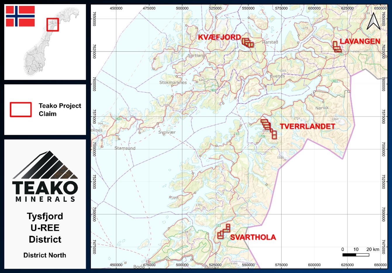
Figure 1: Location map of the Svarthola, Tverrlandet, Lavangen and Kvæfjord Projects
To view an enhanced version of this graphic, please visit:
https://images.newsfilecorp.com/files/8258/276172_teako1en.jpg
1 Spectrometer analyses were performed on select samples which may not be representative of all mineralization hosted within the Projects.
The Svarthola Project
The Svarthola Project is situated approximately 10 km north of the town and port of Fauske in Nordland and contains the Harelifjell occurrence (“Harelifjell”). Mineralization at Harelifjell has been identified as zones of uraninite mineralization within an aplite body. This aplite can be traced up to 1.4 km NE-SW with historic rock-chip grades confirmed up to 5% U (Lindhal 1984)2. The target was to characterize the Harelifjell mineralization, sample the known mineralized areas and map out radiometric anomalies associated with the occurrence, via a high-resolution survey with the GT40.
Mineralization consists of fracture zones and dark black biotite-uraninite within the aplite body, with U grades from the Company’s survey reaching 7,114 ppm (Figure 2). Historical drilling failed to replicate surface grades and raised questions about depth continuity. However, to the northeast of Harelifjell the GT40 also identified areas with U enrichment at significantly lower topographical elevation, suggesting greater potential depth continuity of mineralization than previously thought at Harelifjell. This second area of enrichment highlights the strike potential of the Svarthola Project, with initial exploration confirming U potential over a minimum 1 km strike length.
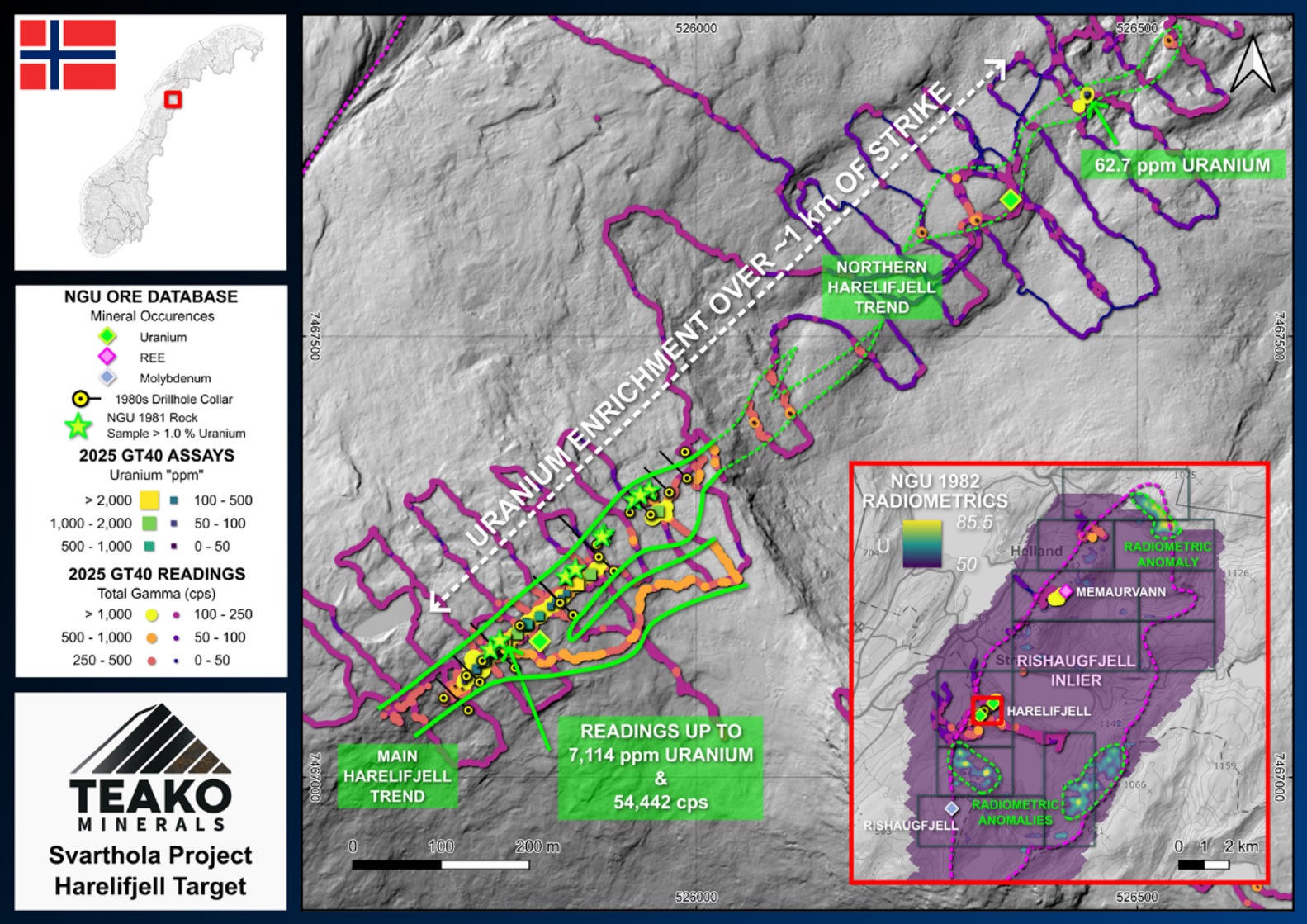
Figure 2: Svarthola Project map highlighting the potential strike length of mineralization at Harelifjell. The inset map shows the radiometric data across the Svarthola Project highlighting further potential across the region (radiometric data edited to present only highest data).
To view an enhanced version of this graphic, please visit:
https://images.newsfilecorp.com/files/8258/276172_teako2en.jpg
The Tverrlandet Project
At the Tverrlandet Project, which is situated approximately 45 km southwest of Narvik, the focus was to assess the rare earth elements (“REE”) and U potential of the northern Tysfjord basement window, within the TIB-2 granites. Historical soil geochemistry data collected by the Norwegian Geological Survey (the “NGU”) identified local soil anomalies reading up to 19.2 ppm U2, recorded around the area the Teako field crew focussed its exploration efforts.
The results of the GT40 survey of the area showed U enrichment in and around pegmatites, with elevated gamma readings identified around the new Kulhornet target (Figure 3). The general locations and elevated values of the uranium in the soil data provided by the NGU raises questions regarding the source of these elevated values, if they are also linked to pegmatites, or if there is a second source of uranium in this region.
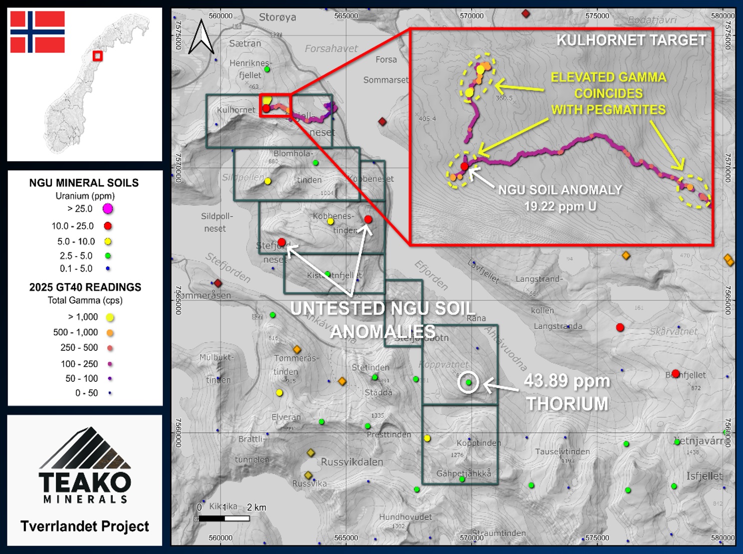
Figure 3: Tverrlandet Project map with NGU soil sampling data (Finne & Eggen, 2013) overlain, with select GT40 survey readings across the area of investigation (inset)
To view an enhanced version of this graphic, please visit:
https://images.newsfilecorp.com/files/8258/276172_teako3en.jpg
The Lavangen Project
The Lavangen Project is situated 37 km north of the major port of Narvik and hosts the pegmatite hosted Spansdalen uranium occurrence, the focus base of this initial investigation. Radiometric studies of this area in the 1980’s highlighted the Spansdalen occurrence to contain values reaching 2543 ppm U (Lindhal 1983)2.
Rock samples taken by the NGU in the 1990’s also revealed uranium grades up to 1155 ppm2. The goal was to assess the historical Spansdalen occurrence with the GT40 and extend this survey over select areas of interest. The GT40 results showed readings of mineralization (up to 930 ppm U1) (Figure 4).
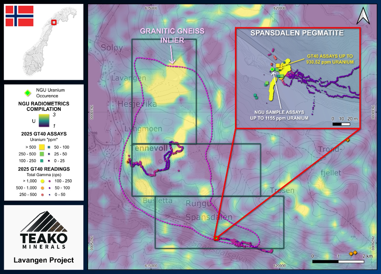
Figure 4: Lavangen Project overview highlighting the granitic gneiss inlier over the project area. Radiometric data from the NGU has been altered to show the highest values.
To view an enhanced version of this graphic, please visit:
https://images.newsfilecorp.com/files/8258/276172_teako4en.jpg
Within the Spansdalen occurrence uranium and molybdenum mineralization was identified by field crews within fracture zones (Figure 5). This enrichment may suggest that the pegmatites at the Lavangen Project are part of a system of later phase or evolved pegmatitic intrusions with structures present across the project area. The orientation of this outcropping mineralization indicates the potential for strike extension to the northeast.
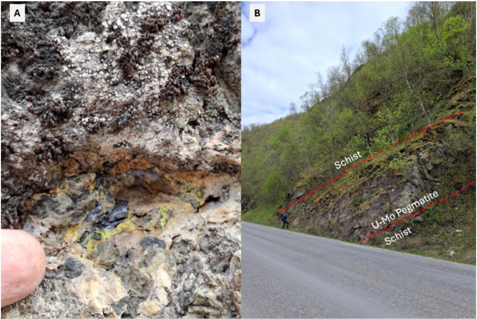
Figure 5: Outcropping molybdenite and secondary uranium mineralization within the Spansdalen pegmatite
To view an enhanced version of this graphic, please visit:
https://images.newsfilecorp.com/files/8258/276172_teako5en.jpg
The Kvæfjord Project
At the Kvæfjord Project, which lies approximately 10 km west of the town of Harstad, exploration efforts concentrated around the historical Berg disseminated sulphide deposit, with a renewed focus on its uranium potential. Historic work around the old workings was focussed on base metal extraction with chalcopyrite and pyrrhotite being the main sulphides present. Uraninite mineralization has been found around the Berg deposit itself with the NGU reporting mineralization up to 9181 ppm U and with work in 1982 reporting grades of 0.3% U (Often, 1982)2.
The GT40 survey over the area identified uranium with assay function data (reaching 24 ppm1). These data were compared to regional and historical data which highlights untested areas with promising radiometric data, with the largest anomaly being in the northern part of the Project (Figure 6).
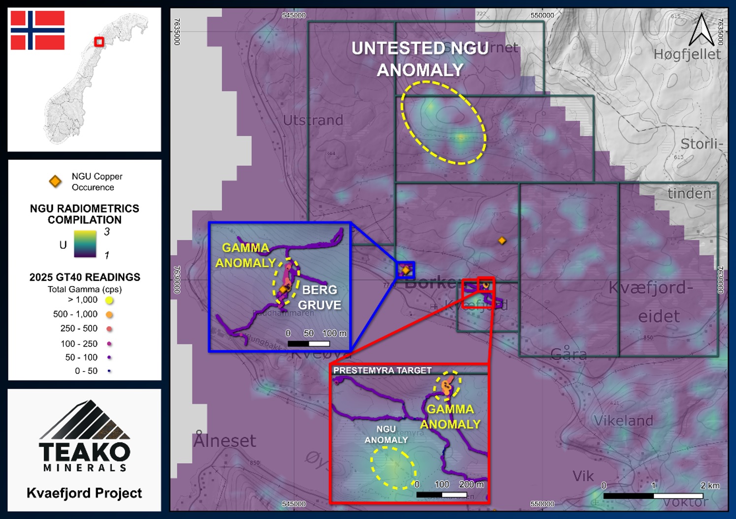
Figure 6: Overview of the Kvæfjord project with inset of the area of investigation with the GT40. The background radiometric map has been edited to highlight the highest U values, indicating multiple areas of interest over the project.
To view an enhanced version of this graphic, please visit:
https://images.newsfilecorp.com/files/8258/276172_teako6en.jpg
2 The Company has not undertaken sufficient analytical work to confirm reported historical assay results, but believes these to be reliable and relevant to the discussion on known mineralization at the Projects.
Qualified Persons and Disclosure Statement
The technical information presented in this news release has been prepared in accordance with Canadian regulatory requirements as set out in National Instrument 43-101 (“NI 43-101”) Standards of Disclosure for Mineral Projects, and reviewed and approved by Eric Roth, a Non-Executive Director of Teako and Qualified Person under NI 43- 101. Mr. Roth holds a Ph.D. in Economic Geology from the University of Western Australia, is a Fellow of the Australian Institute of Mining and Metallurgy (AusIMM), and is a Fellow of the Society of Economic Geologists. Mr. Roth has over 35 years of experience in international minerals exploration and mining project evaluation.
About Teako Minerals Corp.:
Teako Minerals Corp. is a Vancouver-based mineral exploration company committed to acquiring, exploring, and developing mineral properties in Norway, focusing on critical metals such as copper, cobalt, zinc and molybdenum. By leveraging leading-edge exploration technologies and strategic partnerships, Teako aims to address the growing demand for essential minerals while generating value for shareholders and stakeholders alike.
Teako’s Project Hub, including the Løkken and Venna main projects, covers an extensive land package prospective for copper, cobalt, zinc, gold, platinum group elements (or “PGE”), uranium, antimony, molybdenum and rare-earth-elements.
The Project Hub strategy was initially developed from the Company’s first-mover advantage in-country, leveraging both technical skill and strong local community engagement to acquire and advance groups of both core and non-core assets. Core assets such as the Løkken-Venna district remain integral to the Company’s self-funded exploration programs, whereas the Company aims to retain exposure to exploration success on non-core assets through securing deals with strong partners. These deals, if secured, are intended to potentially bring in capital and/or ongoing cash flow, retain upside exposure, and reduce overall risk, thereby strengthening Teako’s foundation. Teako holds a 10% economic interest in the Hulderdalen, Moelva, Kvelde and Skåråfjell projects owned by Fritzøe Skoger AS.
Contact Information:
Sven Gollan – CEO
T: +1 (604)-871-4301
Email: sven.gollan@teakominerals.com
Forward-Looking Information:
This press release may include forward-looking information within the meaning of Canadian securities legislation, concerning the business of Teako. Forward-looking information is based on certain key expectations and assumptions made by the management of Teako. In some cases, you can identify forward-looking statements by the use of words such as “will,” “may,” “would,” “expect,” “intend,” “plan,” “seek,” “anticipate,” “believe,” “estimate,” “predict,” “potential,” “continue,” “likely,” “could” and variations of these terms and similar expressions, or the negative of these terms or similar expressions. Forward-looking statements in this press release include statements related to (i) the Company’s expectations and views with respect to certain mining jurisdictions, future transactions and the Company’s plans. Although Teako believes that the expectations and assumptions on which such forward-looking information is based are reasonable, undue reliance should not be placed on the forward-looking information because Teako can give no assurance that they will prove to be correct. Since forward-looking statements address future events and conditions, by their very nature, they involve inherent risks and uncertainties. Actual results could differ materially from those currently anticipated due to a number of factors and risks. These include but are not limited to, risks associated with the mineral exploration industry in general (e.g., operational risks in development, exploration and production; the uncertainty of mineral resource estimates; the uncertainty of estimates and projections relating to production, costs and expenses, and health, safety and environmental risks), constraint in the availability of services, commodity price and exchange rate fluctuations, changes in legislation impacting the mining industry, adverse weather conditions and uncertainties resulting from potential delays or changes in plans with respect to exploration or development projects or capital expenditures. These and other risks are set out in more detail in Teako’s interim Management’s Discussion and Analysis, July 31, 2025.
All dollar figures included herein are presented in Canadian dollars, unless otherwise noted. Neither the CSE nor its market regulator accepts responsibility for the adequacy or accuracy of this press release.
References
Lindahl, I. (1983) Radiometriske bilmålinger i Troms 1983. NGU Rapport 84.062. Trondheim: Norges Geologiske Undersøkelse.
Often, M. (1982) Geologiske undersøkelser og diamantboring ved Berg Gruve, Borkenes. NGU Rapport BV1151 Trondheim: Norges geologiske undersøkelse.
Finne, T.-E. & Eggen, O. A. (2013) Soil geochemical data from Nord-Salten, Nordland. NGU Rapport 2013.015. Trondheim: Geological Survey of Norway (for data used in figures)
Lindahl, I. (1984) Rishaugfjellvinduet og Harelifjell uranmineralisering. NGU Rapport 84.057. Trondheim: Norges geologiske undersøkelse
![]()
To view the source version of this press release, please visit https://www.newsfilecorp.com/release/276172